Drive into Boston from the north and you might watch your account get dinged on Route 1 while drivers cruising down I-93 slide into the city for free. That mismatch is not a glitch in the system. It is the legacy of where Massachusetts built toll hardware, which projects needed their own revenue streams, and what state leaders have decided to charge for. The result is a map where a few bridges, tunnels and the Mass Pike cost you money while other major routes stay toll-free.
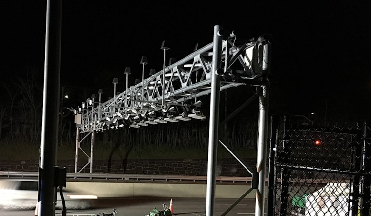
The toll spots are very specific: the Massachusetts Turnpike (I-90), the Tobin Memorial Bridge on U.S. Route 1, and the Sumner, Callahan and Ted Williams tunnels to East Boston, all run through the state's electronic tolling system. According to EZDriveMA, these locations are on the official toll network and now rely entirely on electronic collection by transponder or license plate image. That setup means anyone crossing the Tobin or diving into one of the harbor tunnels will get a bill that a driver rolling in on I-93 never sees.
Where the patchwork came from
Massachusetts tolls were built around specific financing needs, especially the Turnpike and the harbor crossings, not as part of one grand cordon-style plan around downtown Boston. A 2017 proposal to put electronic gantries on I-93 and other approaches to the city died at the State House, which left that interstate effectively toll-free. As reported by WCVB, that legislative history is a big reason the current toll map looks so uneven.
Politics and the funding crunch
Any talk of expanding tolls tends to light up the political radar. Gov. Maura Healey publicly rejected the idea of border tolls after the concept surfaced inside her own administration, according to WBUR. A statewide transportation funding task force also stopped short of backing congestion pricing as something to roll out right away. As GBH noted, the group instead called for more study and analysis rather than rushing into new user fees.
What a congestion toll looks like elsewhere
Supporters of congestion pricing keep pointing to New York City as the live test case. There, congestion pricing launched in January 2025 and has cut the number of vehicles entering the zone while also pulling in significant new transit funding. According to the governor's office, the first year brought large speed improvements at many of the river crossings and generated more than $500 million in net revenue that is being used for MTA capital projects and upgrades. Those results are what Massachusetts advocates want Beacon Hill to examine before designing anything closer to home.
Local advocates weigh in
“The proof is in the pudding,” TransitMatters executive director Caitlin Allen-Connelly told WCVB, arguing that the early New York numbers showed faster trips for both drivers and transit riders. Maha Aslam, the Transit + Streets program manager at LivableStreets, told the station she expects that conversations about congestion pricing “are imminent,” and LivableStreets lists Aslam as its Transit + Streets program manager on its staff page.
What's next on Beacon Hill
On paper, lawmakers are already warming up the topic. Bills have been filed to study or pilot roadway pricing and to create new bodies that would design equitable approaches. One measure, S.2354, would set up a board to examine where regional pricing might go, what it would cost and how it would affect different communities. As reported by Boston Newsroom, any real change is still several steps away, with years of study, committee votes and public hearings likely in front of it.
For now, the bottom line is simple: where you pay a toll in Boston is the product of past construction decisions and political calls. If the state eventually embraces congestion pricing or another user-fee system, the map of who pays and where could look very different, but that fight is still very much in progress.


