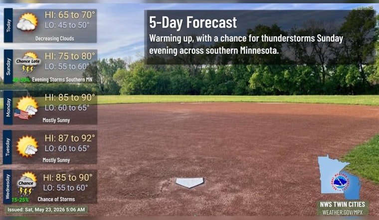
Minneapolis wakes up cloudy and cool this morning, with temperatures in the mid 50s and a chance of light rain before dawn. Through Saturday, May 23, expect mostly cloudy skies and a high near 69°F, with southwest winds around 10 mph in the afternoon. The real headline comes later: temperatures ramp up quickly through the weekend, hitting the 80s on Sunday and building into a hot Memorial Day and early week stretch, with the best signal for lower 90s on Tuesday, May 26.
Today and the commute
Morning commuters across most of the metro should stay mostly dry, although areas along and east of I-35 could see brief, nuisance showers before mid morning. Clouds are expected to break up some in the afternoon, with highs around 69°F and southwest winds near 10 mph, so most outdoor plans should be in good shape.
Where showers do pop up, bridges, bike lanes and other exposed surfaces may be a little slick for a short time, so a light layer and a small umbrella are still smart to have on hand. For more local context and how we got here, check out our earlier windy chill preview.
Weekend and Memorial Day outlook
Warmer air moves in Sunday, May 24, with highs near 82°F. The warmup continues into Memorial Day, Monday, May 25, when highs are expected to reach the upper 80s. Forecasters say the hottest day of the stretch is likely Tuesday, May 26, when readings could climb into the lower 90s, with rain chances still on the low side.
There is a slight chance of scattered, disorganized thunderstorms at times early next week, but no widespread rain is expected. These details come from the National Weather Service Twin Cities.
Plan ahead
There are no watches or warnings in effect for the Twin Cities at the moment, so outdoor events can go on as scheduled. That said, it is worth planning for heat on Monday and Tuesday - bring water, find shade where you can, and keep an eye on kids and older adults.
If you have early morning Memorial Day activities, expect comfortable starts with much hotter afternoons, so consider shifting the most strenuous plans earlier in the day or building in cooling breaks. Keep checking forecasts if you are organizing large gatherings, since a few spotty storms cannot be ruled out next week.
Bottom line: a few light sprinkles for some this morning, then a mostly dry Saturday that flips quickly into a run of heat for the holiday weekend. We will update if any watches are issued or if the storm signal strengthens.


