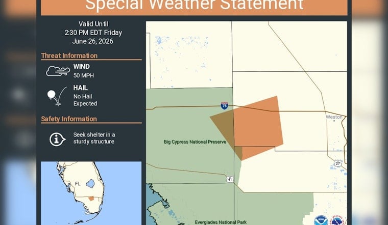
The National Weather Service office in Miami put Broward County on alert Friday afternoon, issuing a special weather statement that runs through 2:30 p.m. EDT. Forecasters warned that fast-moving thunderstorms were capable of producing sudden wind gusts near 50 mph and urged anyone in the path of the storms to head inside sturdy buildings. Hail was not expected with this particular round of weather.
According to a post from NWS Miami, the statement covers all of Broward County and remains in effect until 2:30 p.m. EDT. The agency advised people to move indoors, avoid driving through heavy downpours and lightning while storms are overhead, and to treat any downed power lines as live hazards.
What to expect
Radar-indicated storm cores associated with this system can produce damaging wind gusts and frequent lightning. Forecasters estimated gusts near 50 mph with brief, stronger bursts possible, though they did not flag hail as a primary concern. As outlined by the National Weather Service Miami, winds of that strength can knock down small tree limbs and send unsecured objects flying, leading to localized power outages and tricky travel conditions. Drivers are urged to avoid flooded roadways and to let the storm cores move through before getting back on the road.
Recent local pattern
This latest alert fits into a broader June pattern of quick-hitting storms that have triggered short-fuse notices across South Florida, including earlier warnings for gusty thunderstorms with similar wind estimates. Earlier this month, Hail and 50-mph gusts in Broward County led to tree damage and scattered outages. Local forecasters say the combination of heat, humidity, and passing disturbances will keep the late-afternoon storm threat alive through the weekend.
Residents who live or work in Broward County can sign up for alerts and emergency information via Broward County Emergency Management. If you encounter a downed line or serious damage, call 911, and use the county hotline for non-emergency storm impacts. For the rest of the afternoon, it is worth keeping one eye on the radar and another on updates from the National Weather Service.


