Minneapolis started Tuesday wrapped in patchy fog and sticky air, and the day is only ramping up from there. Skies are expected to turn mostly sunny this afternoon with highs near 90°F, an Air Quality Alert for elevated ozone is in place, and a round of late-night storms, some potentially strong, is on track to roll through overnight into Wednesday. If your plans involve being outside, keep them flexible, take it easy during the hottest hours, and be ready to head inside once storms fire up.
Foggy Morning, Hot Afternoon
Patchy fog could cut visibility for the early commute, but it should thin by mid-morning across much of the metro. After that, expect mostly sunny skies and temperatures pushing into the upper 80s to near 90°F, with light east-southeast winds generally under 10 mph. Higher humidity will make it feel hotter, especially in low-lying spots and densely built neighborhoods where the heat likes to linger.
Air Quality Alert For Ozone
The Minnesota Pollution Control Agency has issued an Air Quality Alert for elevated ozone across the Twin Cities from noon to 9 p.m. Tuesday. Sensitive groups, including people with lung or heart disease, older adults, children, and anyone who is very active outside, should limit prolonged or heavy outdoor exertion and look for ways to cut back on activities that add pollution. For current readings and guidance, see the Minnesota Pollution Control Agency advisory.
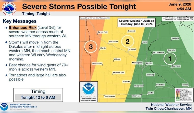
Thunderstorms Tonight Into Wednesday Morning
A line of showers and thunderstorms is expected to develop late Tuesday and charge east overnight, with the strongest storms most likely between about 1 a.m. and 4 a.m. Wednesday. Damaging straight-line winds will be the main severe threat, although large hail and a few tornadoes remain possible in the stronger cells. Wednesday stays hot, with highs near 91°F and gusts that could reach around 30 mph in some spots. For timing details and any watches or warnings, see the latest forecast discussion from the National Weather Service Twin Cities.
How To Plan
If you have early-morning errands or outdoor events, keep an easy backup plan to move indoors and avoid driving through any standing water that develops. For outdoor workouts, target the morning hours before ozone and heat peak, drink plenty of water, and check local updates this evening in case storms trigger new watches or warnings.


