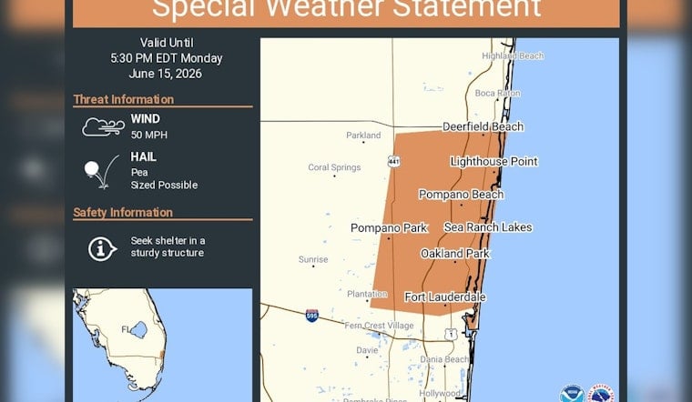
Northern Broward County is in for a rough ride Monday afternoon, with a fast-moving cluster of storms prompting a special weather statement for Fort Lauderdale, Pompano Beach and Sunrise through 5:30 p.m. EDT. Forecasters say the strongest storm cores could spit out pea-sized hail and whip up wind gusts near 50 mph, strong enough to snap small limbs and send unsecured patio furniture briefly airborne. Residents are urged to hunker down in sturdy buildings while the cells race through.
A special weather statement has been issued for Fort Lauderdale FL, Pompano Beach FL and Sunrise FL until 5:30 PM EDT https://t.co/NIit6hAR2u
— NWS Miami (@NWSMiami) June 15, 2026
What the NWS is flagging
According to NWS Miami on X, the special weather statement highlights pea-sized hail and wind gusts up to about 50 mph as the main hazards. The advisory specifically calls out Fort Lauderdale, Pompano Beach and Sunrise and instructs people in the path of the stronger cells to "seek shelter in a sturdy structure" until the storms pass. The statement is scheduled to expire at 5:30 p.m. EDT.
Local risks and how to ride it out
Winds in the 50 mph range can knock down small branches, toss loose debris and trigger brief power outages or minor damage to anything left unsecured outside. Broward County Emergency Management urges residents to enroll in local alert systems, move vehicles away from large trees when possible and steer clear of driving through standing water until conditions settle down.
Watching the radar for upgrades
The current statement could be bumped up if radar starts showing even stronger storm cores, so residents are encouraged to keep tabs on live radar and short-term forecasts through the evening. Fresh updates and product pages are available directly from NWS Miami.


