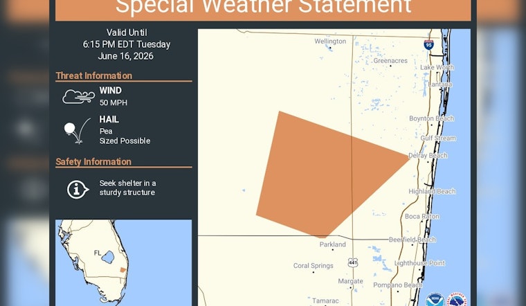
Late Tuesday afternoon, fast-moving thunderstorms muscled into Palm Beach County, prompting the National Weather Service in Miami to fire off a special weather statement warning of 50 mph gusts and pockets of pea-size hail. The short-fuse alert, issued for the evening rush, was valid through 6:15 p.m. EDT and urged residents in the path of the storms to head indoors and secure anything that could blow around.
A special weather statement has been issued for Palm Beach County, FL until 6:15 PM EDT https://t.co/lNSWJzbjZm
— NWS Miami (@NWSMiami) June 16, 2026
Special Weather Statement: Hazards And Timing
According to a Special Weather Statement from the National Weather Service, radar at 5:18 p.m. EDT showed storms capable of producing 45 to 50 mph wind gusts and pea-size hail over parts of northern Broward and southeastern Palm Beach County. The bulletin specifically called out Delray Beach and Boca Raton, warning that the stronger cells could snap small tree limbs and send unsecured outdoor items tumbling down streets and across yards.
Forecasters noted that the same storm cluster prompting the advisory could pulse up or down in intensity as it tracked inland, which is why they opted for a tightly focused statement with a 6:15 p.m. EDT expiration instead of a broader, longer-lasting watch. The Miami forecast office echoed that timing in an evening post on its X feed, reinforcing the heads-up for anyone still out on the roads or wrapping up after-work errands.
Where The Threat Is Concentrated
These thunderstorm cores tend to be narrow but punchy, delivering brief blasts of hail and damaging wind as they roll in off the Atlantic and push across the urban corridor. Local coverage of gusty storms barreling into West Palm, Boynton and Jupiter has highlighted how late-afternoon sea-breeze collisions can flip the switch from sunny skies to sideways rain with almost no warning.
That quick-hitting pattern helps explain why the Weather Service often leans on short, surgical Special Weather Statements for these pulses instead of rolling out larger-scale watches that might not reflect how localized the nastiest wind and hail really are.
How To Stay Safe
If you are in the area flagged by the advisory, the American Red Cross recommends moving into a sturdy building and staying away from windows until the storm is clearly past. Drivers are urged to avoid water-covered roads and steer clear of any downed power lines, which should be treated as live until crews say otherwise.
Parking vehicles away from large trees or overhanging branches can cut the risk of damage from falling limbs, and a quick sweep of patios and balconies to secure chairs, umbrellas and planters can keep the wind from turning them into airborne projectiles. If you do have to be outside, keep your time exposed to a minimum and monitor official updates on your phone or local media.
Residents are encouraged to watch for follow-up products from local emergency managers and the NWS Miami office in case the storms ramp up or new warnings are issued. Reports of hail, snapped limbs or localized flooding can be passed along to local authorities, who relay those ground-truth observations to forecasters refining the next round of alerts.


