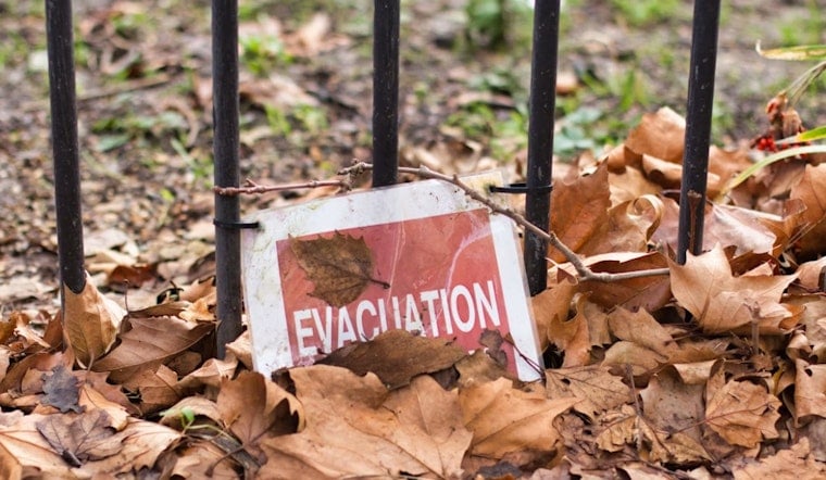
Bright red evacuation-zone signs are popping up along roads near Mount Diablo, giving residents a blunt reminder that wildfire season is not theoretical anymore. The San Ramon Valley Fire Protection District has started posting the markers on routes into communities tucked against the base of the hills, hoping the signs turn evacuation planning into a habit instead of a last-minute panic.
Local crews have planted roughly 50 signs across neighborhoods that back up to the Diablo foothills, including places like Diablo, Blackhawk and Camino Tassajara. One roadside marker spells it out clearly: “You are entering Evacuation Zone CCC E269.” Fire Chief Jonas Aguiar told reporters the new signs target areas with heavy fuels and limited ways out, and the district plans to run evacuation drills in high-risk neighborhoods this summer as forecasts point to winds that could trigger a Red Flag Warning. A Danville resident who lives off Camino Tassajara said the area’s few exits make it especially vulnerable if a fast-moving fire hits, as reported by CBS San Francisco.
The district's Evacuation Zones page describes the signs as part of a public-awareness push and urges residents to memorize their numeric zone and sign up for alerts through the Genasys mapping platform. It lays out simple preparedness steps like knowing your zone, making a family plan and packing a go-bag, and it points users to tools for pulling up their zone on a smartphone, as outlined by the San Ramon Valley Fire Protection District.
How the zones and alerts work
The numbered zones tie directly into a mapping and mass-notification system that lets officials send targeted warnings to people in a specific area instead of blasting the whole region. Downloading the Genasys Protect app or registering with local alert services lets your phone receive automatic updates when your zone status changes, as explained on the Genasys Protect / Zonehaven page.
Why exits matter
A UC Santa Barbara study published this year found that wildfire fatalities drop sharply as communities gain more outward road access, but only up to about six exits. That creates a stark risk for neighborhoods with limited egress. The researchers estimate about 17.7 million Americans live in communities below that six-exit threshold, a finding that helps explain why planners and fire agencies are pouring energy into both escape routes and fuel reduction, according to UC Santa Barbara.
What residents should do
The district recommends locking in your zone number, subscribing to local alert services and rehearsing an evacuation plan so the first time you drive out is not during a real emergency. It also advises clearing defensible space, keeping a go-bag ready and making arrangements for pets. For step-by-step tools and the full zone map, see the San Ramon Valley Fire Protection District page.
The signs will not stop fires, but officials say those bright red reminders, combined with drills, can shave precious minutes off chaotic evacuations. In a wind-driven blaze, when embers hop across roads and slopes in seconds, researchers and local officials say realistic training and reliable, targeted alerts are among the most effective steps communities can take this summer to keep people alive.


