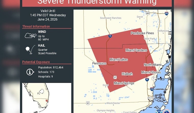
The National Weather Service office in Miami issued a severe thunderstorm warning Wednesday that put a huge swath of the metro area on alert, including Hialeah, Pembroke Pines and Miramar. The warning targeted northern Miami-Dade and southern Broward counties as a line of storms muscled through in the early afternoon, with residents urged to head indoors and skip flooded streets while gusty winds and hail rolled across neighborhoods.
The warning, in effect until 1:45 p.m. EDT, called for wind gusts up to 60 mph and hail up to the size of a U.S. quarter. It covered roughly 812,464 people, along with nine hospitals and 173 schools, according to NWS Miami.
Aviso de Tormenta Severa incluye Hialeah FL, Pembroke Pines FL, Miramar FL hasta la 1:45 PM EDT
— NWS Miami (@NWSMiami) June 24, 2026
What To Expect And What Experts Recommend
Strong downbursts can topple trees and loft debris in seconds, and lightning and flash flooding often tag along with these cells. The American Red Cross advises moving to a sturdy building or an interior room away from windows, avoiding plumbing and electrical appliances during the storm, and waiting at least 30 minutes after the last thunder before resuming outdoor activities, per American Red Cross.
Local Tips For Drivers And Parents
Drivers should slow down, pull over if visibility collapses, and never drive through standing water. Parents should keep children inside and confirm pick-up plans if schools are affected. Miami-Dade emergency management notes residents can report downed power lines and flooding through 311 or the county’s Neighborhood Damage Assessment form, and encourages checking local school and transit alerts before heading out, according to Miami-Dade County Department of Emergency Management.
Keep an eye on radar apps or local television for updates. If severe weather is heading your way, move indoors immediately and secure loose outdoor items. We will monitor updates from forecasters and local agencies through the afternoon as conditions evolve.


