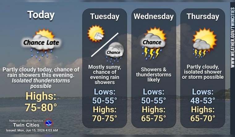
Minneapolis woke up to a crisp, clear Monday morning, with temperatures in the mid‑50s and plenty of blue sky overhead. This afternoon is set to warm into the upper 70s, near 79, under mostly sunny skies, putting one of the nicest days of the week front and center before the pattern flips cooler and wetter. West to southwest winds will kick up later in the day around 5 to 15 mph, so expect a breezy finish to your sunshine.
This Afternoon And Evening
Through the afternoon, winds strengthen from the west to west‑southwest, with gusts picking up into the late day and early evening. Unsecured tents and lightweight patio umbrellas could get a workout. Scattered showers and a few isolated thunderstorms are possible after about 7 p.m., with the better shot at rain overnight and into early Tuesday morning. Forecasters put shower chances late tonight around 50%. According to the National Weather Service Twin Cities, most of the metro should stay dry for much of the day, but rain odds climb once the sun goes down.
Wednesday Rain Threat
The next, more widespread round of rain shows up Wednesday, when showers and thunderstorms are likely and highs only reach near 71. Heavier bands could drop a half inch to three‑quarters of an inch in spots, so midweek outdoor events, lawn work, and any backyard grilling plans may end up competing with soggy conditions.
Plan Ahead
During the heavier downpours, plan for wet roads and some standing water, and build in extra travel time for Monday evening plans and especially for Wednesday commutes. Metro Transit riders should keep an eye on service alerts, and KMSP passengers may run into periods of lower ceilings and reduced visibility that could affect some flights. Before you head out, check for updates through Metro Transit.


