Chicago woke up Tuesday, June 9, 2026, to a preview of what is shaping up to be a steamy stretch. Early this morning, Midway was already reporting fog and mist, a muggy 72°F, and visibility around 5 miles. Through the afternoon, expect partly sunny skies with a high near 86°F and only a slight chance of a brief shower or thunderstorm. Most neighborhoods stay dry, but the real headline is a rapid warmup from Wednesday into Thursday that sends inland highs into the low 90s and pushes heat index values into the mid to upper 90s while opening the door for bouts of stronger storms.
Afternoon Commute And Evening Plans
This afternoon feels solidly summerlike, with sticky air and light southwest breezes that keep inland spots noticeably warmer than the lakefront. Any isolated shower that pops up should be short lived, although a quick downpour could briefly knock down visibility and slow the evening commute in the unlucky few areas that get hit. If you have outdoor plans tonight, it is worth having an easy indoor backup in case lightning or a sudden gusty cell rolls through.
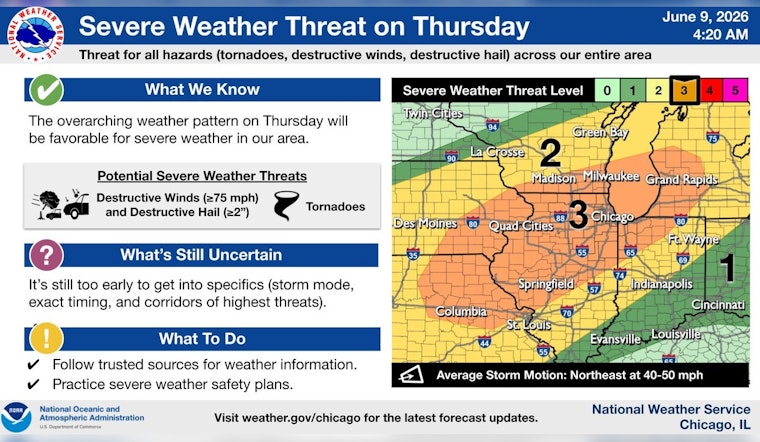
Wednesday To Thursday Heat And Severe Risk
The atmosphere turns hotter and more unstable on Wednesday, with highs near 90 to 92°F and peak "feels like" readings climbing into the mid to upper 90s. Late day thunderstorms could turn strong. Forecasters expect multiple rounds of thunderstorms from Tuesday night through Thursday, and Thursday currently carries the highest concern for more widespread severe storms, according to NWS Chicago. Stronger storms may bring damaging gusts of 25 to 30 mph or higher along with locally heavy rainfall where storms repeatedly track over the same neighborhoods.
Staying Cool And Weather Smart
If you or someone you look after does not have air conditioning, plan ahead for the hottest hours by heading to an air conditioned public space and checking local listings for available sites. Drink plenty of water, avoid strenuous outdoor work during peak heat, and secure lightweight outdoor items before gusty storms move in. For a neighborhood list of public cooling locations and hours, visit the City of Chicago cooling centers.
Quick Forecast
Today: Partly sunny with a high near 86°F and a slight (about 20%) chance of afternoon showers.
Tonight: Mostly cloudy with a low around 68°F and a 40% chance of showers and a few thunderstorms.
Wednesday to Thursday: Hot, with highs in the upper 80s to lower 90s and heat index values approaching the mid 90s to around 100. The risk of strong to severe storms increases Wednesday night into Thursday, with locally heavy rain possible.
Friday to Saturday: Cooler and drier, with highs easing back into the upper 70s to mid 80s and more comfortable humidity.


