A tight, spinning tornado dropped out of the sky near the tiny Putnam County towns of Lucerne and Unionville on Wednesday afternoon, triggering emergency alerts across north-central Missouri and sending locals scrambling for shelter while others hit record on their phones. By the time the storm moved on, neighbors and local crews were talking about downed trees, a damaged shed and a snapped power line stretched across the landscape.
At about 4:20 p.m. CDT, the National Weather Service office in Kansas City/Pleasant Hill issued a tornado warning for central Putnam County, stating, "At 420 PM CDT, a confirmed dangerous tornado was located near Unionville, moving east at 30 mph." The bulletin was flagged as a "particularly dangerous situation" and urged anyone in Unionville, Worthington and Livonia to get to shelter immediately.
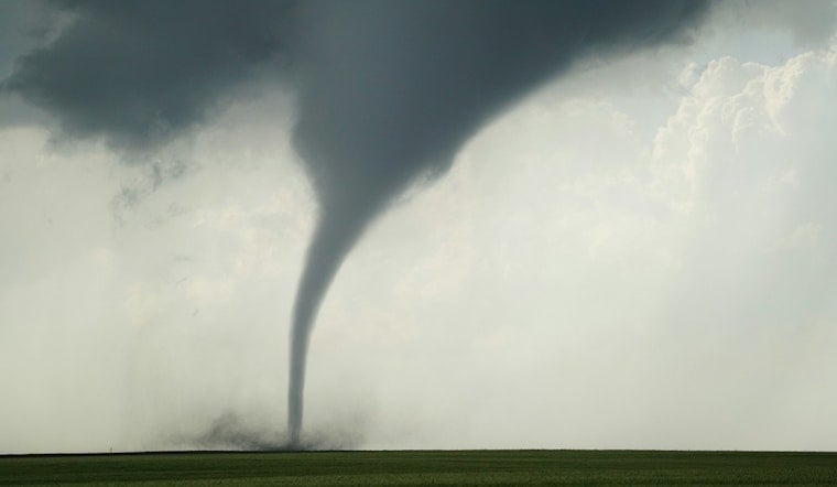
Video And Warnings
Viewer video quickly started circulating. One clip posted by KMBC, credited to Bryant Burough, shows a low-hanging funnel with obvious rotation near Lucerne, churning over open fields. A separate short clip shared by AccuWeather captures the funnel pulling debris upward as it tightens.
Farther east, neighbors near Jameson described a jarring few minutes as the storms rolled through. They told KCTV5 their home felt "like somebody had a vacuum unit hooked up to the whole house trying to suck the insides out," and said a shed was destroyed while a power line was dragged across the highway. The station's First Warn 5 Weather team reported multiple tornado sightings across its viewing area Wednesday as crews and the National Weather Service began organizing damage surveys.
Storm Context And Next Steps
Forecasters had already circled the region for trouble. Much of northern Missouri spent the evening under Tornado Watch 303, which highlighted an enhanced risk for large hail, damaging winds and a few tornadoes. WeatherBug carried the watch details and accompanying National Weather Service language about the severe threat.
Survey teams from the National Weather Service are expected to fan out across affected counties once conditions are safe, checking damage patterns to confirm any touchdowns and assign intensity ratings. Those ratings help map the storm’s path and give residents a clearer sense of what tore through their fields and fencerows.
Local officials are asking anyone who safely can to share photos, videos or reports of storm damage with emergency management or the National Weather Service to assist with mapping and recovery work. Emergency managers are also repeating a familiar but critical warning: stay away from downed power lines and unstable debris until utility and public works crews can clear roads and restore service.


