

























































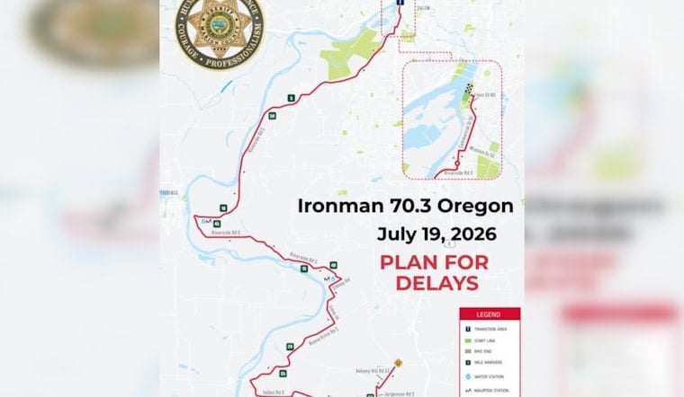
Salem residents and visitors are in for a very different kind of Sunday drive as IRONMAN 70.3 Oregon rolls through town, threading its way across Riverfront Park, Minto‑Brown Island and River Road. An early‑morning swim start and a long bike leg will bring partial road closures and slower traffic through much of the day.
Road Closures, Start Time and Where to Expect Delays
The race starts early, with the swim kicking off at 6 a.m. in Riverfront Park. Race‑day impacts are expected from about 6 a.m. to 4 p.m., according to Travel Salem. Signs will be posted near Riverfront Park and Minto‑Brown Island Park to warn drivers and pedestrians about closures, and the Peter Courtney pedestrian bridge will be closed on race day.
Alternate Routes and Safety Guidance
Marion County law enforcement is urging drivers to take alternate routes and slow down through the south Salem area. A recommended detour runs from Front Street to River Road South, Sidney Road South, Buena Vista Road South, Talbot Road South and Ankeny Hill Road SE, according to a post from the Marion County Sheriff's Office on Facebook. Deputies and event staff will be stationed along the course to help direct traffic. Drivers should plan for delays and build in extra time for trips on Sunday.
Race Course and Why River Road Is Impacted
IRONMAN describes the Salem course as a 1.2‑mile downriver swim in the Willamette River, followed by a 56‑mile bike ride headed south on River Road toward the Ankeny Natural Wildlife Refuge, and then a 13.1‑mile run from Riverfront Park through Minto‑Brown Island Park and back. That long stretch on the bike is the main reason south Salem neighborhoods and county roads will feel the impact. Riders and support vehicles may temporarily block shoulders and intersections as the race moves through.
Boaters, Businesses and How to Get Around
Boaters should expect limited river access during the swim portion of the race and may see posted advisories at local ramps, according to the Oregon State Marine Board. Local hotels, restaurants and delivery services have been urged to factor the race into their Sunday schedules and routes, since getting across town could take longer than usual. For visitors planning to watch the finish, Travel Salem provides maps and parking details. If you have the option, it is best to avoid River Road South during the mid‑morning surge when most athletes are on the bike and run legs.
How to Stay Informed
For real‑time updates and the official detour map, residents are encouraged to follow the Marion County Sheriff's Office and the event pages maintained by IRONMAN. Officials also urge drivers and pedestrians to obey flaggers and posted signage, which are the final word on when a lane reopens.





