

























































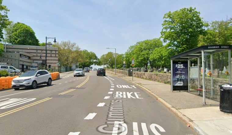
After roughly two years of reconstruction, a one-mile stretch of Cummins Highway in Mattapan now feels a lot less like a mini-expressway and a lot more like a neighborhood street. The corridor between Mattapan Square and Mount Calvary Cemetery has been narrowed and fitted with protected bike lanes, raised crosswalks, and fresh plantings that swap out big slabs of asphalt for rain-soaking gardens.
The City of Boston's Public Works Department says planning for the project started in spring 2019, with full reconstruction work beginning in spring 2024. This spring, crews focused on sidewalks, ramps, and getting the roadway ready for paving. According to the city's project page, those construction milestones were originally set to wrap up in 2026, following months of coordination with residents and design refinements. City of Boston Public Works Department
Recent photos of the nearly finished corridor show a new roundabout where Cummins Highway meets Greenfield Road and Weybosset Street, a signalized crosswalk linking two bus stops, continuous protected bike lanes, raised side-street crossings, and new stormwater gardens. Streetsblog Massachusetts documented the changes on July 17 and noted that the one-mile stretch is expected to grow from roughly 21 street trees to more than 100 once all plantings are in.
The safety case for a road diet
The rebuild grew out of long-running safety problems. City crash mapping puts the Mattapan section of Cummins on Boston's high-crash network, and official analyses found that drivers routinely pushed well past safe speeds on the wide, four-lane layout. The danger was driven home when a person riding a bicycle was struck and killed near Richmere Road on June 9, 2020, an incident reported at the time by local media. CBS Boston
City officials have pointed residents to the collision map and project pages to explore the crash history that helped justify shifting to a two-lane, traffic-calmed design. City of Boston crash map
What the new street looks like
The final design trades long, exposed crossings for shorter, raised crosswalks and adds continuous, protected bike lanes that are separated from traffic by planting buffers and, where there is room, on-street parking. New stormwater treatment gardens and wider tree pits have already taken over thousands of square feet of former asphalt, and the expanded tree canopy is meant to cool the corridor while also encouraging drivers to slow down. Streetsblog Massachusetts highlighted many of these features on the nearly complete roadway.
What comes next
Crews are now focused on finishing landscaping, planting, and accessibility details as the city gears up for a final paving and cleanup push. Public works managers say they will continue to track speeds and crash patterns on the rebuilt corridor to measure the safety impact and adjust the design if needed. City of Boston Public Works Department
For people who live and travel along Cummins, the shift is already clear: sidewalks and bus stops are more accessible, bike space is protected, and small community gardens are starting to fill in the new buffers. It is a visible sign that a once fast highway has been recast to better serve people on foot, on bikes, and on transit.





