

























































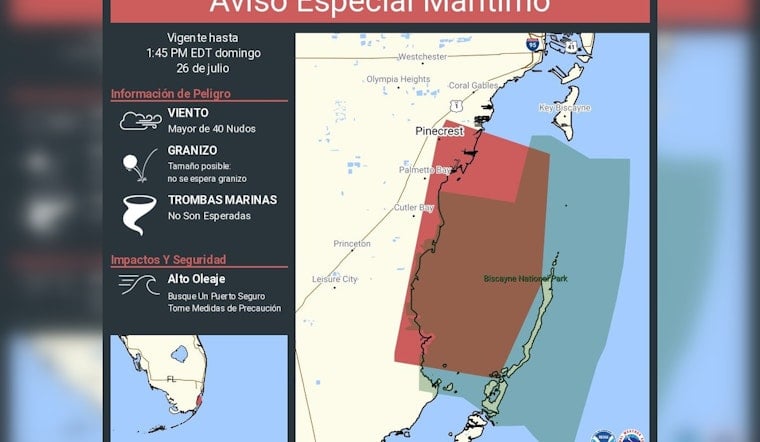
The National Weather Service office in Miami briefly turned a calm Sunday on Biscayne Bay into a scramble for shelter, issuing an "Aviso Especial Marítimo" in Spanish for the bay and nearby coastal waters. The advisory, active through 1:45 p.m. EDT, warned of rapidly developing hazardous marine conditions and elevated waves, with wind gusts that forecasters said could exceed 40 knots. Small recreational boats were urged to head for safe harbor and secure their vessels as seas turned choppy in exposed areas.
According to NWS Miami, the Spanish-language post specifically named Biscayne National Park, Key Biscayne, Coral Gables, Olympia Heights and Westchester among the areas included in the alert zone and advised mariners to "seek a safe harbor and take precautions." The post warned that high waves and hazardous marine conditions could damage small craft. The office published the advisory on X at about 1:18 p.m. EDT Sunday, giving boaters less than half an hour of lead time before the bulletin expired.
Where the warning applied
The alert covered Biscayne Bay and a wide swath of Miami-Dade coastal waters, calling out neighborhoods from Pinecrest and Palmetto Bay down to Cutler Bay, Princeton and Leisure City as part of the zone of concern. NWS marine zoning maps list Biscayne Bay as AMZ630, and that zone is a frequent target for short-notice marine warnings during convective summer storms, according to the marine page on weather.gov. Mariners tied up in marinas along the Gold Coast, along with visitors heading for Biscayne National Park, were urged to monitor conditions and delay outings until the bulletin expired.
Winds, waves and safety risks
Forecasters said winds in the affected areas could top 40 knots, a setup that can quickly build higher waves and unleash sudden gusts capable of flipping or damaging small craft, according to NWS Miami. The advisory noted that waterspouts were not expected with this particular event. Even so, heavy downpours and rapidly rising seas remained likely. Small powerboats and skiffs were flagged as most vulnerable, while larger vessels could still run into rough and hazardous seas in exposed stretches of water.
Why short-fuse warnings are common in July
South Florida's summer weather pattern leans heavily on sea breezes colliding over very warm water, a combination that routinely sparks compact thunderstorms that can strengthen within minutes. Those fast-developing cells are exactly the kind of short-notice hazard that triggers Special Marine Warnings. The Miami forecast office has long studied local waterspout patterns and reports that spout activity and quick-hitting squalls peak in the rainy season, making vigilance on the water especially important in July, according to NWS Miami research. Local climatology and routine marine forecasts help explain why boaters are urged to keep an eye on brief advisories even on days that start out looking calm.
If you are on the water when a Special Marine Warning is issued, the official guidance is straightforward: "move to safe harbor until hazardous weather passes," as stated in NWS marine products on weather.gov. The U.S. Coast Guard offers similar advice for pleasure craft when severe winds or seas threaten local ports, according to the U.S. Coast Guard. Officials encourage mariners to report severe conditions to the Coast Guard or to the NWS so forecasters can update warnings for others still on the water.
We will post updates if the Miami forecast office expands or extends the advisory. Until then, mariners and coastal residents are urged to stay tuned to official forecasts and use extra caution along the waterfront.





