

























































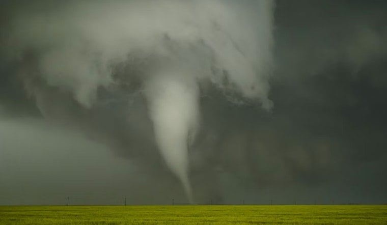
A video posted to Facebook and timestamped at 9:35 a.m. yesterday appears to show a funnel cloud swirling over Lake St. Clair near Harsens Island, just as a cold front pushed through Southeast Michigan and raised the odds of exactly this kind of weather. Whether the spinning column of air stayed out over the water or dragged ashore on the island remains unclear, with local agencies staying quiet so far.
The video was posted by an anonymous user on the Michigan Storm Chasers Facebook page, according to The Detroit News. The page initially described the phenomenon as a potential waterspout, then called it a waterspout outright in a later post. The National Weather Service was unavailable for immediate comment on the sighting, per the same report.
Neither the Clay Township Police Department nor the Harsens Island Fire Department provided comment when asked about the incident, leaving open the question of whether the waterspout moved ashore and caused any damage. Harsens Island sits within Clay Township, a St. Clair County community that recorded a population of 8,446 in the 2020 Census, and its marshy delta location draws heavy recreational boat traffic that would have had a close-up view of Saturday's funnel.
What the Forecast Already Warned Was Coming
The setup had been flagged hours earlier. The National Weather Service's morning severe weather outlook for Southeast Michigan warned that showers and thunderstorms were expected across the region Saturday morning and afternoon, with small hail, localized flooding, and damaging wind gusts up to 60 miles per hour all possible, the outlook noted. The Detroit/Pontiac office's Lake St. Clair marine forecast had separately flagged a slight chance of waterspouts developing after 8 a.m. as the cold front arrived, a detail Hoodline reported was part of a broader pattern of waterspout warnings across the Great Lakes this week.
The National Weather Service distinguishes tornadic waterspouts from the more common fair-weather variety. Tornadic waterspouts are tornadoes that either form over water or move from land onto water, and they carry the same characteristics as land tornadoes, according to the agency. They're associated with severe thunderstorms and are often accompanied by high winds, high seas, large hail, and frequent dangerous lightning, the National Weather Service says. Fair-weather waterspouts, by contrast, make up roughly 85% of all reported spouts and build upward from the water surface under cumulus clouds rather than descending from a rotating storm system.
Why the Distinction Matters for Warnings
That classification isn't just academic. Under National Weather Service protocol, forecasters issue Special Marine Warnings for waterspouts that stay over open water, but the alert converts to a full Tornado Warning the moment the circulation moves toward or touches land. That threshold is exactly why the unanswered question of landfall on Harsens Island carries weight beyond curiosity — it determines which warning system, and which level of urgency, applies.
Saturday's sighting also lands squarely in what's typically the busiest stretch for these funnels. Late August through October is peak season for Great Lakes waterspouts, as autumn cold-air outbreaks move over lake water that has just reached its warmest temperatures of the year, creating the sharp instability spouts need to form. The extreme end of that pattern played out between September 28 and October 4, 2020, when the International Centre for Waterspout Research documented 232 waterspouts and funnel clouds over just seven days.
A Busy Year for Michigan Twisters
The Lake St. Clair sighting also arrives during an unusually active severe weather year statewide. Michigan had already confirmed 21 tornadoes by mid-June, well above the state's historical annual average of 13 to 16, a pace tracked by CBS News Detroit. Michigan has seen precedent for a waterspout crossing onto land before: in a Hoodline report from May, National Weather Service surveyors confirmed an EF-0 tornadic waterspout on Big Bradford Lake in Otsego County that clipped the shoreline with peak winds of 65 mph.
Detection remains a persistent challenge for these fast-forming funnels. Doppler radar often fails to catch low-level waterspouts or brief landspouts because the beam from the National Weather Service's White Lake radar scans thousands of feet above the surface at distances around 70 miles, meaning many spouts are confirmed only after the fact through video and eyewitness reports rather than automated warnings. That gap is part of why Saturday's Facebook footage, rather than an official alert, became the first public record of the event.
For now, the core facts remain unresolved. The video appears to show a funnel cloud near Harsens Island in Lake St. Clair, storm chasers on social media labeled it a waterspout, and the forecast that morning had already raised the possibility — but whether it ever reached land, and whether it caused any damage, has not been confirmed by either local emergency agency.




