

























































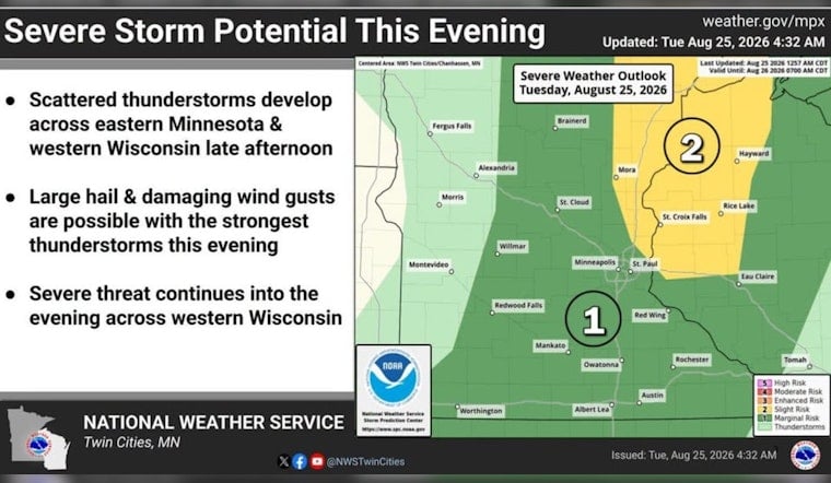
Minneapolis starts Tuesday under mostly cloudy skies and temperatures around 70, but the day is headed for a warm, potentially rough finish. Sunshine should break through and push the high near 87, with thunderstorms possible late afternoon into evening across eastern Minnesota.
Storms Could Arrive After The Afternoon Commute
The National Weather Service Twin Cities/Chanhassen office says storms are most likely to develop near Interstate 35 and the St. Croix River valley around 4 to 5 p.m. Tuesday before moving east through the evening. The strongest storms could bring large hail and damaging wind gusts; a tornado cannot be ruled out, though hail and wind are the bigger concerns, according to the National Weather Service.
For Minneapolis, much of the day may stay dry, but outdoor plans after midafternoon deserve a backup plan. Storms are expected to clear the area between roughly 10 p.m. and midnight, and no watches or warnings are in effect in Minnesota or Wisconsin at the forecast time.
Cooler, Quieter Midweek Weather
Wednesday brings a noticeable step down to around 80, with partly sunny skies and only a slight chance of a brief rain shower around 3 to 4 p.m. Wednesday night falls to near 61, then Thursday and Friday look sunny and seasonable with highs around 81 and 82.
Weekend Storm Chances Return
Showers and thunderstorms return to the forecast Friday night through Monday, with 40% chances Friday night and Saturday, followed by a warm Sunday near 85 and Monday near 84. The weekend setup is more scattered than Tuesday’s front, but repeated storm chances could complicate outdoor plans across the Twin Cities.





