

























































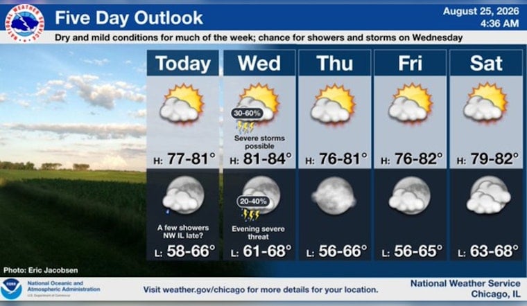
Chicago starts Tuesday, August 25, with mostly cloudy skies and temperatures near 63 degrees before a mostly sunny afternoon pushes the mercury to about 76. South to southwest winds will run around 5 to 10 mph, making for a comfortable day before the weather takes a more unsettled turn Wednesday.
Wednesday Brings The Week’s Main Storm Threat
A cold front is expected to cross the area Wednesday afternoon and evening, bringing a chance of showers and thunderstorms. The National Weather Service says some storms could become strong to severe, with localized damaging winds, large hail and brief heavy downpours possible.
The greatest severe-weather concern is east of Interstate 55 and south of Interstate 80, though storm coverage and timing remain uncertain across the Chicago area. A tornado cannot be ruled out with the strongest storms, while the forecast calls for gusts up to 20 mph even outside of thunderstorms.
Cooler And Calmer Weather Follows
Any lingering showers or storms should fade Wednesday night, leaving mostly clear skies and a low near 67. Thursday looks sunny and seasonably cooler, with a high around 76, followed by another sunny day Friday near 75.
The weekend warms back up, with mostly sunny skies and a high near 80 Saturday. Sunday and Monday turn warmer, reaching about 84 and 85 degrees, respectively, with periodic chances for showers and thunderstorms returning to the forecast.
No Active Weather Alerts
There are no watches, warnings or advisories in effect for Illinois, Indiana or Lake Michigan in the current forecast. For outdoor plans, Tuesday is the easy pick; Wednesday afternoon and evening will require a closer look at the radar and a backup plan.





