

























































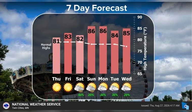
Minneapolis is starting Thursday, August 27, with mostly cloudy skies and temperatures in the mid-60s, but the clouds should give way to a sunny, seasonably warm afternoon. The high is expected to reach about 81 degrees, with light northwest winds and no rain in the forecast.
Sunny Thursday, Cooler Night
Temperatures should climb through the 70s late this morning and reach the low 80s by midafternoon. The National Weather Service says patchy fog could develop in low-lying areas and near bodies of water Thursday morning and again Friday morning, although no weather advisories are posted.
Friday Night Kicks Off A Wetter Stretch
Friday, August 28, stays sunny and warmer, with a high near 84 and only a slight chance of daytime rain. After 7 p.m., showers and thunderstorms become possible, with a 50% chance of precipitation and rainfall totals generally between a tenth and a quarter inch.
Saturday Looks Like The Weekend’s Stormiest Day
Showers and thunderstorms are likely before 1 p.m. Saturday, August 29, with a 60% chance of rain and possible rainfall totals between a quarter and half inch. The day should still reach about 82 degrees, but south winds of 10 to 15 mph could make outdoor plans feel a bit less leisurely. Forecasters say strong to severe storms do not appear likely at this time, but Saturday is the day to keep an eye on the sky.
Heat Returns Sunday And Stays Into Next Week
Sunday, August 30, brings partly sunny skies and a high near 87, with only a slight chance of an evening shower or thunderstorm. Monday through Wednesday remain warm, with highs in the mid-80s and scattered 20% to 30% rain chances, making the week ahead more hit-or-miss than a steady washout.
For Thursday’s commute and outdoor plans, the forecast is the easy part: dry pavement, improving sunshine and light winds. The bigger weather decision arrives Friday night and Saturday, when checking for updates before heading out will be worthwhile.





