

























































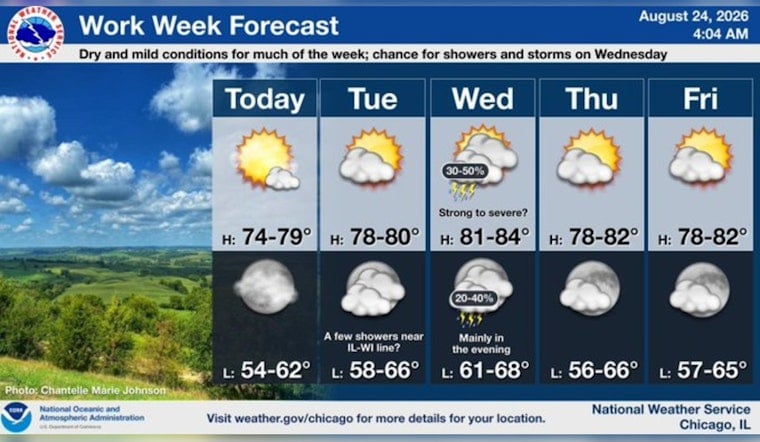
Chicago is waking up to mostly clear skies and a cool 59 degrees early Monday, with a sunny afternoon ahead. Temperatures should climb to around 74 degrees before a comfortable evening sets in across the city.
Sunny Monday Brings A Brief Weather Reset
North winds will run 5 to 10 mph, keeping the day seasonably mild and dry. A lake breeze may push inland during the afternoon and evening, bringing some extra cooling near the lakefront and potentially shifting winds toward the east.
Monday night should stay mostly clear, with temperatures falling to around 61 degrees and light southeast winds. There are no watches, warnings or advisories in effect for Chicago, according to the National Weather Service Chicago/Romeoville.
Warmer Tuesday Leads Into Midweek Storm Chances
Tuesday looks mostly sunny and warmer, with a high near 79 degrees and light south winds. The bigger forecast change arrives Wednesday, when temperatures may reach 83 degrees and a cold front brings a 40% chance of showers and thunderstorms.
Wednesday's storms are expected to be scattered rather than a citywide washout, but some could become strong and produce gusty winds. The forecast calls for gusts up to 20 mph, while the National Weather Service discussion notes that a few storms could become locally severe during the afternoon and evening.
Clearer Skies Return Thursday
Rain chances should taper Wednesday night, followed by mostly clear skies and a low near 67 degrees. Thursday and Friday then look sunny and cooler, with highs near 78 degrees before another slight chance of thunderstorms arrives Saturday afternoon and more unsettled weather develops Sunday.





