

























































Minneapolis is waking up clear and mild Tuesday, with temperatures near 68 degrees before the city climbs toward 89 by afternoon. The bigger change arrives overnight, when rain showers become likely after midnight and summerlike weather gives way to a stormier stretch.
A Special Weather Statement from the National Weather Service says dense fog could briefly cut visibility to a quarter-mile or less in parts of central and southern Minnesota and western Wisconsin through 8 a.m. Tuesday. Drivers should slow down and leave extra time, with the fog expected to dissipate by morning.
Hot, Mostly Sunny Tuesday
Once the fog clears, mostly sunny skies and light west winds will take over. Afternoon temperatures should hover in the upper 80s, with the warmest stretch arriving during the midafternoon before clouds increase late in the day.
Rain And Storms Arrive Overnight
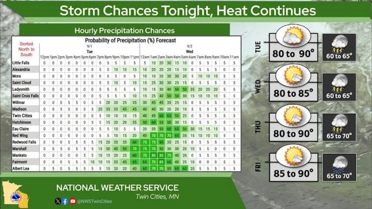
Showers are likely after midnight Tuesday, with a 60% chance of precipitation and possible rainfall totals between a tenth and a quarter inch. The strongest storms are expected to favor southern Minnesota, but forecast guidance has shown some potential for activity to reach the southern Twin Cities metro.
If storms move into the metro, forecasters say damaging winds would be the primary concern. No watches, warnings or advisories are listed for Minnesota or Wisconsin beyond the morning fog statement.
Brief Midweek Cooldown Before More Heat
Wednesday will be mostly sunny and cooler, with a high near 84 degrees, but the break from the heat will be short-lived. Showers and thunderstorms could return Wednesday night, followed by another 87-degree day Thursday and a 50% chance of rain or storms, especially during the morning.
Labor Day Weekend Stays Warm And Unsettled
Summerlike temperatures continue through the holiday weekend, with highs near 89 Friday, 88 Saturday and 84 Sunday. Storm chances are highest Friday morning, while Saturday and Sunday bring lower but still meaningful chances for scattered showers and thunderstorms.
Labor Day should be cooler, with a high near 79 and a slight chance of showers or thunderstorms. The forecast remains unsettled enough that anyone making outdoor plans should keep an eye on timing changes as the weekend approaches.




