Get the latest local stories in your inbox.
Weather & Environment in ...
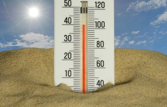
Patchy morning fog gives way to mid‑80s in downtown LA today. Heat advisories start Sunday, with an extreme heat watch midweek and a small chance of mountain storms.
A brush fire near Piru burned about 50 acres and prompted evacuation warnings east of Lake Piru. Aircraft and more than 100 firefighters are battling the blaze in steep terrain.
The Bureau of Land Management approved a plan to repurpose a buried Mojave pipeline for water transport to Southern California, prompting sharp criticism from tribes and conservationists.
Muggy mornings and highs near 87°F today. A Heat Advisory runs through July 14 and an Extreme Heat Watch starts July 14–16 for inland areas.
CDC warns dust storms can kick up spores that cause Valley fever across the Southwest. Health officials and vets say take precautions for people and pets during dusty weather.
The San Gabriel Valley district will release about 480,000 non-biting male mosquitoes in Bassett over 16 weeks to cut Aedes populations.
Downtown LA will warm into the upper 80s today as a Heat Advisory lingers. Morning fog gives way to hot afternoons; city cooling centers are available.
An Extreme Heat Watch covers large parts of Southern California July 14–16, with inland triple-digit highs expected. Officials urge hydration, cooling plans and extra care for workers and vulnerable people.
Weeks-long south swell stripped sand from beaches from San Clemente to Santa Cruz, exposing rock, collapsing bluffs and prompting emergency coastal work.
A Heat Advisory runs July 8–10 for Downtown LA; inland highs will reach upper 80s–low 90s. Call 2-1-1 for cooling centers and avoid midday outdoor exertion.
A semi‑truck fire on northbound I‑5 near Templin Highway spread into brush and prompted an evacuation warning for Paradise Ranch Estates, with lane closures snarling traffic.
Morning fog gives way to sunny, hot afternoons; Heat Advisory runs July 810.
A compact stormwater project at San Pascual would capture runoff and recharge groundwater — but neighbors, tribal leaders and L.A. officials warn it will cost trees and sacred ground.
Newsletter Signup
Enter your email, choose one or more newsletters, and we will only send updates for the metros you select.
* indicates required
Select at least one newsletter.