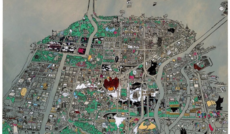
If you haven't figured it out by now, we'll let you in on a secret. We have a thing for cool maps of the city. Here's our new favorite.
This map was commissioned by the SF Arts Commission in 2009. After that, it was in Los Angeles for a while. Here's the concept behind it: California Historical Society
The artist says of Lone Mountain at USF:
California Historical Society
The artist says of Lone Mountain at USF:
This map was commissioned by the SF Arts Commission in 2009. After that, it was in Los Angeles for a while. Here's the concept behind it:
Marci and I and a bunch of other friends were asked by the San Francisco Arts Commission to make work around the theme of "Trace Elements". The idea around "Trace Elements" or what I took from it was how people don't know about the history of things that they might pass by on the street, or how things got to where they were at and how things might have been forgotten (yeah, like Frodo and the Ring, only not). So I thought I'd make a Secret Map of San Francisco. Pretty much like anyone who's lived or lived near San Francisco there's little bits of history you learn about that can easily be placed on a map. Like walking pass Alamo Square you see folks taking photos of the "Full House" Houses, or if you're near Dolores Park you'll notice the golden fire hydrant that saved the San Francisco.Read more at the link. Here's a closeup of the hood:
California Historical SocietyOf Note: 1. Lone Mountain Cemeteries- Pretty much where USF sits now is where there used to be the cemeteries of Lone Mountain. As San Francisco grew they passed city ordinances to remove the cemeteries. The bodies were dug up and re-interred in Colma and other parts of San Mateo County.Now you know!


