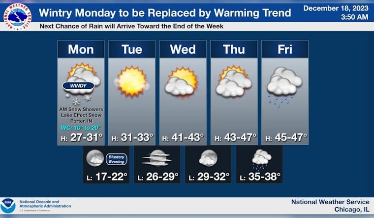
Chicago braces for a wintry wallop as gusty winds and snow flurries are forecasted to batter the area, according to the National Weather Service. Commuters faced a tough Monday morning drive with scattered snow and significant wind gusts creating treacherous driving conditions.
Monday's temperatures are set to dive with a high near 29 degrees by afternoon and plummet even further to a low of around 20 degrees at night, as noted by NBC Chicago. The National Weather Service had issued a wind advisory for Porter and Lake Counties in Indiana, warning of northwest winds of 20 to 30 miles per hour, with gusts as high as 45 miles per hour.
A hazardous weather outlook was also put in place by the National Weather Service with elevated wind and snow risk cited for Porter County, Indiana. "A strong storm system will induce scattered snow showers across parts of northern IL," the service cautions. Officials expect the windiest conditions along Lake Michigan, where a mixed bag of snow showers could severely reduce visibility and cause travel disruptions.
The rest of the week is looking equally challenging, weather-wise. Chicagoans should expect increasing clouds on Tuesday and mostly sunny skies by Wednesday, with temperatures climbing to the mid-40s later in the week. However, rain is on the horizon starting Thursday night, according to the forecast from the National Weather Service. The frigid combo of snow and wind seems to be preparing to give Chicagoland its rough prelude to winter.
As the days progress, locals ought to stay vigilant on the roads, especially during commutes. "Be careful if driving this morning - there are snow showers leading to brief but dramatic changes in road conditions," a tweet from the National Weather Service warned. With holiday traffic imminent, drivers and pedestrians alike should be prepared for a potential onslaught of treacherous weather ahead.


