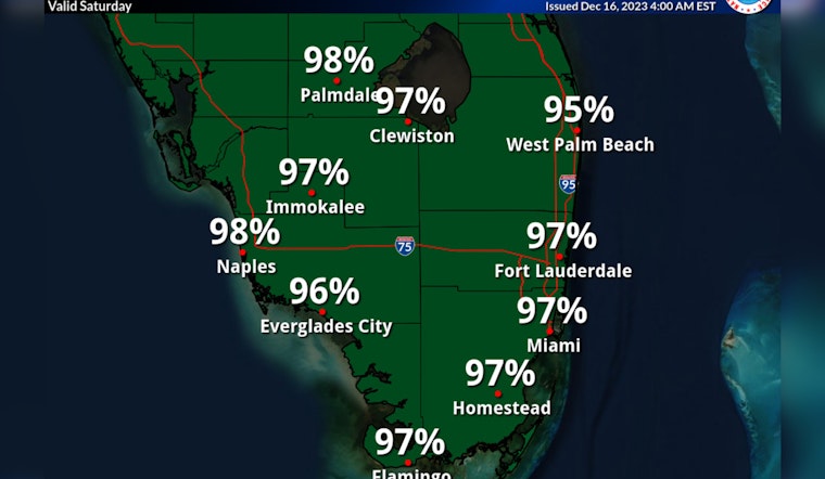
Miami is bracing for severe weather as forecasts predict a combination of heavy rain, strong winds, and tumultuous surf throughout the weekend. The National Weather Service has issued a flood watch in effect until Sunday morning, cautioning residents to prepare for substantial rainfall, expected to reach between 3 and 6 inches. According to their detailed forecast, thunderstorms are likely to follow, with a high chance of downpours and gusts reaching 36 mph.
Moreover, a wind advisory and gale warning stretch into Sunday morning, coupled with a high surf advisory until 7 a.m. Breakers could surge to 14 feet, and a high risk of rip currents will persist into Sunday evening. "The wind has been the most impactful of the last several days," as reported by NBC Miami, highlighting the persistently strong gusts, which are expected to blow strongly and sometimes to reach speeds of over 40 mph.
NBC Miami also notes that today's weather falls under a level two risk of severe storms on a scale of five. Apart from the threat of flooding and ponding on roads, the storms are capable of flinging wind up to 58 mph and could possibly spawn isolated waterspouts or weak tornadoes. As the morning progresses, scattered showers are expected to give way to heavier rain by midday, with the worst weather predicted through the afternoon and evening hours.
Relief is expected to come by midnight, leading to a potentially clearer Sunday. "Sunday morning, we still have a chance for lingering showers as the cold front swings through," NBC Miami reports, which is likely to "bring back dry air by the afternoon." A subsequent front is set to drop temperatures dramatically by Tuesday, introducing cooler nights with lows in the 50s and temperate highs in the upper 60s to low 70s. But the community must first weather what promises to be a challenging Saturday.


