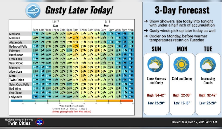
Residents in Minneapolis and surrounding areas should brace themselves for a mix of weather patterns in the upcoming days, from brisk winds and potential snow showers to sunnier skies. According to the National Weather Service's forecast for today, Minneapolitans could experience a few sprinkles after 5 p.m., with patchy fog lifting before mid-morning, the day turning partly sunny with temperatures near 39 degrees and northwest winds reaching a speed of 5 to 15 mph.
Tonight, the city sees a slight chance of rain and snow before 10 p.m., followed by possible flurries until midnight; the temperature will dip to around 19 degrees and winds could become blustery, peaking at 20 mph with gusts that may hit up to 35 mph, creating chills and potentially hazardous travel conditions, especially for commuters and anyone planning to venture outdoors during the evening hours.
Looking ahead to Monday, sunny skies will prevail with a high near 25 degrees, although it will remain windy with a north-northwest wind starting between 15 to 20 mph and decreasing later on to 5 to 10 mph, gusts could still reach up to 30 mph during the day, while Monday night is forecasted to be mostly clear, with a low of around 17 degrees and calmer winds shifting south after midnight, detailed by National Weather Service.
The rest of the week appears more stable, with Tuesday and Wednesday both partly sunny and highs in the mid-30s to low 40s; Thursday sees increased cloud cover and a chance of rain after midnight, transitioning into a 20 percent chance of rain on Friday and partly sunny conditions, with the weekend promising mostly sunny days and highs lingering around 43 degrees.
Despite the mix of conditions starting the week, the National Weather Service's Hazardous Weather Outlook suggests that beyond today and tonight, no hazardous weather is expected for the period of Monday through Saturday, granting a respite to residents who may have been concerned about disruptions due to unfavorable weather patterns.


