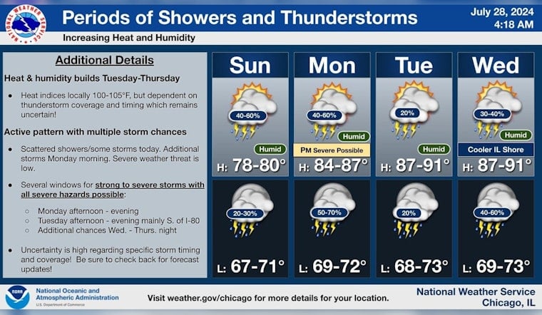
Residents in Chicago and parts of northwest Indiana may need to keep their umbrellas close by and their outdoor plans flexible, as the National Weather Service Chicago/Romeoville IL has issued a detailed forecast predicting variable weather conditions beginning on July 28, 2024. Today's forecast anticipates showers and thunderstorms mainly before 2 pm, with potential for more storms after 5 pm, and a cloudy sky hanging overhead as temperatures reach a high of approximately 79 degrees Fahrenheit.
The Chicago area faces a "Limited Thunderstorm Risk" and a "Limited Flooding Risk," with some storms possibly producing locally heavy rainfall, though severe weather is not expected today. As the forecast extends into the night, chances of precipitation remain significant, but with lesser rainfall amounts expected. The forecast for upcoming days, indicates a monotone of instability, with thunderstorms and heightened temperatures that could, lead to local heat indices surpassing 100 degrees, particularly south of I-80.
Starting Monday and throughout the week, Chicago will continue to see an elevated risk of thunderstorms, especially on Monday afternoon when strong to severe thunderstorms may occur. "All severe hazards are possible," according to the Hazardous Weather Outlook released by the National Weather Service. Residents are advised to stay alert for any weather-related announcements and be prepared for possible disruptions caused by the active weather pattern.
Forecasters caution that along with the risk for thunderstorms, there is also a "Limited Excessive Heat Risk" from Tuesday through Thursday which may particularly affect the area south of I-80. While the likelihood of thunderstorms continues through to Friday, there are multiple opportunities for the weather to change abruptly and severe conditions to develop. As stated by the National Weather Service, this week's general storm motion is expected to move toward the northeast at 25 mph, adding a dynamic element to the local meteorological landscape.
In light of these predictions, the National Weather Service notes that "spotter activation will not be necessary through tonight," but the situation remains subject to change as the week progresses. Boat operators and beachgoers should also be mindful of the "Limited Thunderstorm Risk" mentioned for the Illinois and Indiana nearshore waters along Lake Michigan. Those making plans for the outdoors are encouraged to stay updated with the latest weather forecasts and consider safety first should they encounter stormy conditions.


