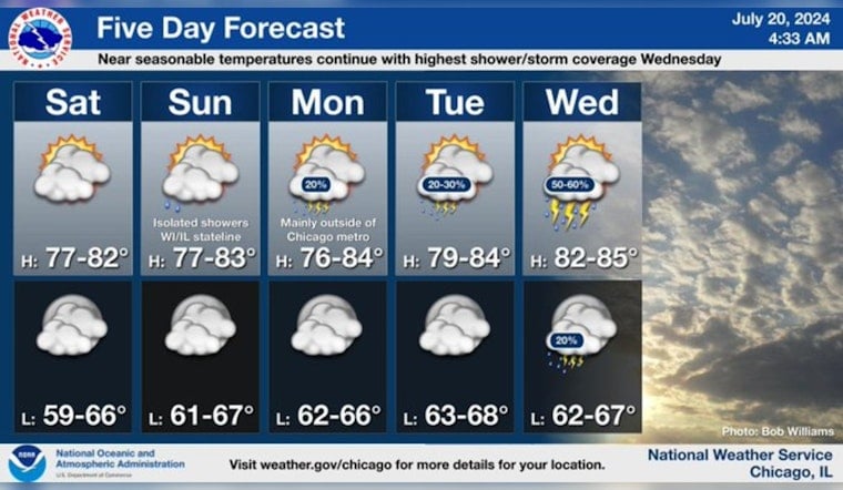
Chicagoans can look forward to a relatively steady weather pattern in the coming days with near-seasonal temperatures and a few chances for rain and storms, particularly midweek. According to the National Weather Service forecast, temperatures this week will hover in the high 70s, with a slightly warmer surge expected on Wednesday, reaching up to about 84 degrees. Today will be partly sunny with a mild high near 78.
Near seasonable temperatures continue with mainly low chances for isolated showers/storms during the workweek with the highest coverage expected Wednesday. #ILwx #INwx pic.twitter.com/Pfy6vTnZVB
— NWS Chicago (@NWSChicago) July 20, 2024
As the week progresses, Chicago residents should prepare to perhaps see some showers. "A chance of showers, with thunderstorms also possible after 1pm," is expected for Wednesday, seeming to be the week's most notable variation in weather, as per the NWS.
While no significant hazards are on the radar today or tonight, a "Limited Thunderstorm Risk at times" is on the cards from Monday through Thursday, as reported by the NWS Hazardous Weather Outlook.
Yet, despite the potential for stormy intervals, no spotter activation will be required, assuring that any upcoming disturbances should stay within manageable limits. The consensus of this week's pattern, as summarized in a post from NWS Chicago, implies "mainly low chances for isolated showers/storms during the workweek with the highest coverage expected Wednesday."


