Chicago residents can look forward to sunny skies and pleasant temperatures with highs near 80 degrees on Friday, according to the National Weather Service. An east wind of 5 to 10 mph will continue into the evening, when conditions are expected to remain mostly clear, transitioning to a south-southeast wind after midnight.
The tranquility is set to extend through Saturday night, with forecasts predicting sunny weather and temperatures reaching a high near 85. However, the National Weather Service has indicated that from Sunday onwards, there will be "a limited flooding risk" and "limited thunderstorm risk." An update from NWS social media stated the return of chances of thunderstorms and humid conditions starting Sunday.
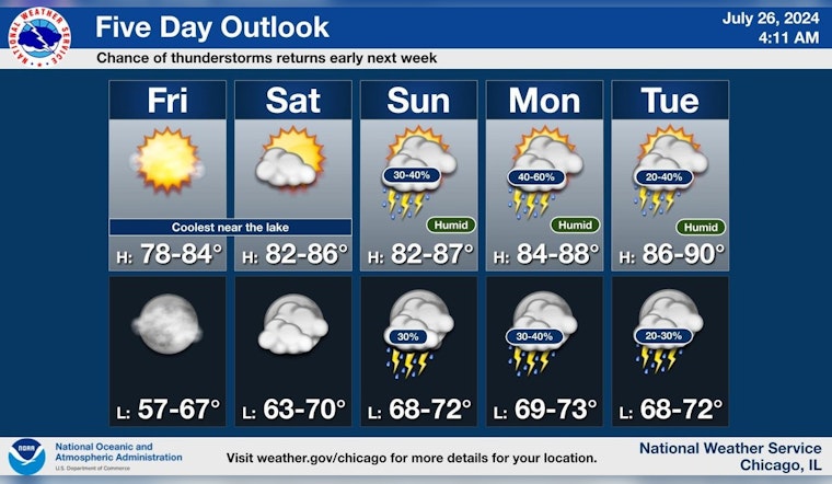
Dry weather is expect through Saturday night. Chance of thunderstorms returns Sunday through the middle of next week along with humid conditions. #ILWX #INWX pic.twitter.com/DADgvYJV8H
— NWS Chicago (@NWSChicago) July 26, 2024
Looking further ahead, the detailed forecast for early next week suggests highs in the upper 80s with ongoing chances of showers and thunderstorms. Particularly on Tuesday and Wednesday, the hazardous weather outlook mentions "Limited Excessive Heat Risk" alongside the storm risks, hinting at rising humidity and temperatures that could pose discomfort or health risks to some individuals.
Water enthusiasts intending to spend time on or near Lake Michigan should note that no hazardous weather is expected today or tonight. However, the Hazardous Weather Outlook does suggest a "Limited Thunderstorm Risk" from Sunday through Wednesday for the Illinois and Indiana nearshore waters.
While spotter activation for the National Weather Service will not be necessary through tonight, locals are encouraged to remain alert to the changing conditions in the coming days. With the forecasted mixed bag of sunshine and storms, Chicagoans should prepare for potentially abrupt weather shifts early next week.


