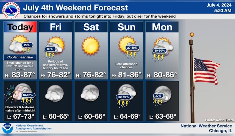
Chicago residents, preparing for the July 4th festivities, should keep an eye on the sky as the National Weather Service forecasts a mix of sun and storms over the holiday weekend. According to the detailed forecast, Independence Day could see a chance of showers before 4 p.m., followed by a slight possibility after 5 p.m., with a reasonably warm high near 80 degrees. Evening plans are more likely to be dampened as there's a 60% chance of showers and possible thunderstorms after 4 a.m., potentially impacting Friday morning activities as well.
Continuing through the weekend, the weather service advises mainly dry conditions on Saturday with a return of storms late Sunday. For those venturing out onto Lake Michigan, the Hazardous Weather Outlook suggests a limited risk of thunderstorms today and tonight, with hazardous conditions for small craft possible on Friday. The general storm motion will be toward the east-northeast at speeds of 25 to 30 mph.
As nighttime celebrations commence, "Isolated thunderstorms may develop near a lake breeze this afternoon, but the highest chances of thunderstorms is expected to be after midnight tonight into early Friday morning, prior to 7 AM CDT," as per the Hazardous Weather Outlook. The forecast for Tuesday and Wednesday remains sunny, with high temperatures hovering around the comfortable 80-degree mark.
An informative post from the NWS Chicago sets the tone for residents, suggesting that while most areas should remain rain-free through the evening, there's a low chance for isolated storms propelled by a lake breeze later in the day. Drier weather is anticipated for most of the weekend, offering a respite before rain chances increase again late Sunday. With the weather in mind, Chicagoans can plan their Independence Day weekend with both outdoor and indoor activities as backup.


