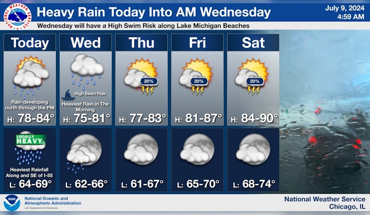
Residents across Chicago are bracing for a bout of severe weather as the National Weather Service issues multiple advisories for the region. Starting today, scattered showers are expected to evolve into potentially severe thunderstorms by the afternoon, with a 60% chance of precipitation and new rainfall amounts ranging from a meager tenth of an inch to significantly higher quantities in storm conditions, according to the Chicago Weather Forecast.
Tonight's forecast predicts an uptick in severity, with heavy showers and a possibility of thunderstorms characterized by strong east winds turning north, and gusts reaching up to 30 mph. Residents should prepare for between 1 and 2 inches of new rainfall, increasing the risk of flooding in some areas, especially along and southeast of Interstate 55 where tropical system Beryl's remnants push northwards, as detailed by the Hazardous Weather Outlook.
Following into Wednesday, the weather scenario does not let up, with an elevated risk of morning flooding and continued turbulence in the form of thunderstorms amid cloudy, then progressively sunnier skies. The Heavy Rain and Flooding Threat in Chicago report emphasizes the likelihood of significant stream and river rises, cautioning citizens against low-lying area inundations. The evening, however, anticipates a decline to a slight chance of thunderstorms and milder, partly cloudy conditions.
A flood watch is in effect along and east-southeast of the I-55 corridor from this afternoon through Wednesday morning due to the threat of very heavy rainfall from the remnants of Beryl. #ILwx #INwx pic.twitter.com/QJ9kkhn5DT
— NWS Chicago (@NWSChicago) July 9, 2024
For those seeking recreation at Lake Michigan's beaches, officials urge caution with a high swim risk alert set for late tonight into Wednesday. Northerly winds from Beryl are to thank for creating hazardous conditions for small craft and increasing the danger of swimming. Boaters and beachgoers alike must heed these pieces of advice to avoid peril. The rest of the week forecasts more sunshine but retains a steady drumbeat of a "limited thunderstorm risk," as the humidity and pass of the tropical remnants give way to a warmer weekend ahead.


