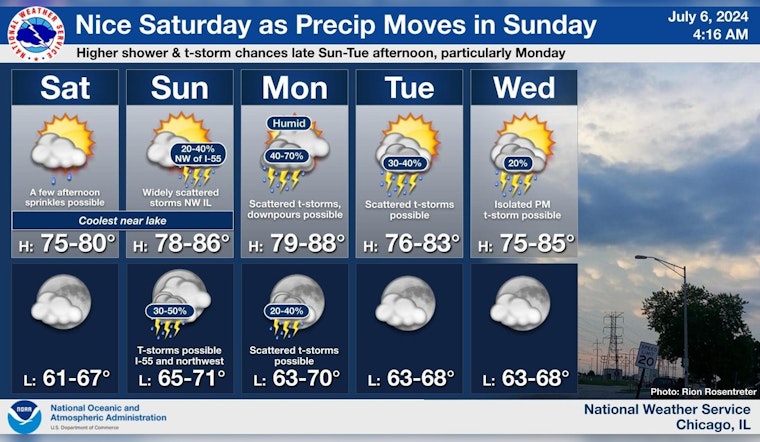
Chicago residents can expect a change in the weather, with a forecast that hints at both sunny spells and the potential rumble of thunderstorms in the coming week. Today's partly sunny skies with a high near 73, may give way to light sprinkles in the afternoon, as the North northwest wind shifts to the east. The National Weather Service's detailed forecast suggests a partly cloudy night ahead, with lows hovering around 66 degrees.
Looking towards Sunday, the risk of showers and possible thunderstorms increases after 4 pm amidst mostly sunny conditions, reaching a warmer high near 82. According to the Hazardous Weather Outlook, there is a limited thunderstorm risk carrying on through Wednesday, despite there being no immediate call for weather spotters.
Monday's forecast indicates the week's peak in storm activity, with a 50 percent chance of showers and thunderstorms. The outlook remains somewhat unsettled through Tuesday, bringing a 30 percent chance of precipitation and a mix of sun and clouds. The evening temperatures for the early part of the week will rest comfortably in the upper 60s. The five-day outlook echoes these predictions, emphasizing Monday as the day with the highest storm potential.
Other than a chance for light sprinkles this afternoon most locations today will remain dry. Shower and storm chances then return Sunday as the next system moves east through the area. The highest chances for storms will be on Monday. #ILwx #INwx pic.twitter.com/bWeB1JkZtU
— NWS Chicago (@NWSChicago) July 6, 2024
Come midweek, the city should prepare for clearer skies, as Wednesday is forecasted to be mostly sunny with a high near 78. As nighttime falls, partly cloudy conditions will continue without sign of the hazardous weather seen in the earlier part of the week. Transitioning into the latter half of the week, Chicagoans will bask in the summer warmth with highs in the upper 70s and lows in the upper 60s, experiencing mostly sunny skies that will carry through to a sunny Friday.


