Chicago residents should prepare to swiftly shuffle between sunblock and umbrellas as the forthcoming week promises a roulette of weather conditions. According to the National Weather Service, the weather today in Chicago is anticipated to be mostly sunny with temperatures peaking at a balmy 88 degrees. However, the serenity of sunshine might be briefly disrupted by isolated showers and thunderstorms post-2 pm, with chances lingering at 20%. A light breeze from the southsoutheast will, before the day progresses, decide to become a southwest wind ranging from 5 to 10 mph.
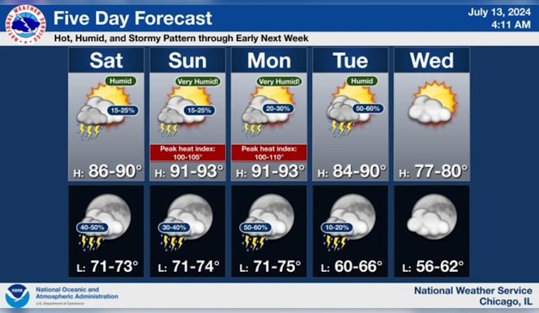
A hot, humid, and at times stormy pattern will prevail through early next week. Our forecast favors the summer-like pattern breaking toward the middle of the week with less humid and more comfortable temperatures returning to the region. #ILwx #INwx pic.twitter.com/JtTEmR7m7q
— NWS Chicago (@NWSChicago) July 13, 2024
As nighttime encroaches, the likelihood of precipitation increases to 50%, with showers and thunderstorms mainly expected after 10 pm. The evening skies will boast a mostly cloudy cover, and temperatures are slated to drop to a low of around 74 degrees, as per the National Weather Service. The southern winds will persist, waving at 5 to 10 mph, and gusts could potentially reach up to 15 mph.
The forecast for Sunday doesn't stray too far off with partly sunny skies and a high near a sweltering 92 degrees. The heat index could make it feel like it's surging to a sizzling 100 degrees. A change in wind direction is not on the horizon as the west-southwest winds will blow steadily at 10 to 15 mph, with gusts possibly achieving up to 20 mph. A 30 percent chance of showers and thunderstorms will remain, primarily before the 10 am mark.
Into Sunday night, the city is predicted to witness partly cloudy conditions with a stable chance of 40 percent for showers and thunderstorms, as reported by the National Weather Service. The weather once again gets hotter on Monday, with the mercury aiming to hit a high near 95 under mostly sunny skies. The heat continues to invite a 30 percent probability of afternoon showers and thunderstorms. Southwestern gusts won't let up, preparing to hit speeds of 5 to 15 mph, accompanied by possible gusts as high as 20 mph.
Monday night's story narrates an increased certainty for showers and thunderstorms at 60%, predominantly before 1 am. Overcast conditions will shadow the low temperature of 75 degrees. As Tuesday rolls in, residents can expect a 50% chance of thunderstorms amidst partly sunny skies and a high of around 87 degrees. The forecast gradually eases the temperatures down throughout the week, landing at a more comfortable zone with highs in the high 70s and clearer skies.


