Chicagoans can expect a mix of sunshine and potential rain showers as they navigate through the upcoming week, according to the latest forecasts. Presently, the city is reveling in a mostly sunny day with the mercury hovering near 78 degrees, coupled with a soft northeast wind transitioning eastward in the morning, as reported by the National Weather Service.
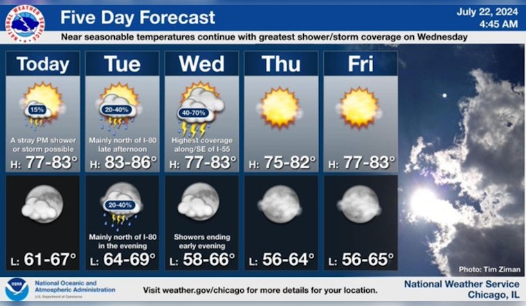
Expect near seasonable temperatures to continue this week. A stray shower or storm can’t be ruled out today though the better coverage is expected north of I-80 late Tuesday and again on Wednesday. Dry conditions then prevail the rest of the week. #ILwx #INwx pic.twitter.com/zyBjvpIw2S
— NWS Chicago (@NWSChicago) July 22, 2024
Tonight's skies will remain mostly clear with lows dipping to around 67 degrees. However, there is a "limited thunderstorm risk" for the region, as sporadic showers or storms could surface this afternoon, the NWS advises. While onlookers might notice developing patchy, dense fog in the interior northern Illinois areas, particularly in rural zones, the fog is expected to lift after the early morning hours, leaving behind near-seasonable temperatures for the rest of the day.
As the week progresses, Tuesday and Wednesday bring a scattered chance of showers and thunderstorms, mainly after 4 pm on Tuesday and again throughout Wednesday with the likelihood of precipitation inching up to 50%. "A stray shower or storm can’t be ruled out today though the better coverage is expected north of I-80 late Tuesday and again on Wednesday," according to the NWS Chicago. Despite this, the forecast anticipates dry conditions to prevail later in the week.


