Chicagoans can expect a mix of sun and clouds over the next few days, along with a creeping thunderstorm risk, according to recent forecasts. The National Weather Service's detailed forecast for Chicago, IL notes that while today will be partly sunny with highs around 78 degrees, tonight's skies will be partly cloudy, with a low around 68 degrees.
The start of the week looks promising with mostly sunny conditions projected for Monday, and similar temperatures carrying over to Tuesday with a slight bump to a high near 84 degrees. However, as the week progresses, there's an increased chance of weather disruptions. "A 20 percent chance of showers and thunderstorms after 1pm," the National Weather Service outlines. Meanwhile, Wednesday could see a 60 percent chance of precipitation, which might mean showers and possibly a thunderstorm later in the day.
In addition to the regular forecasts, a Hazardous Weather Outlook has been issued for parts of north central Illinois, northeast Illinois, and northwest Indiana. Today could witness "Limited Thunderstorm Risk near the Wisconsin stateline," and this pattern could recur through Wednesday. The coming days suggest a persistent although limited chance for storms, as Outlook advises a "Limited Thunderstorm Risk at times."
For those in pursuit of outdoor activities or planning commutes along Lake Michigan, it is noteworthy that no hazardous weather is expected for the nearshore waters through this evening. However the next few days could see some thunderstorm activity, so mariners and beachgoers should stay informed. "Monday through Wednesday... Limited Thunderstorm Risk," as stated in the Hazardous Weather Outlook for Lake Michigan's nearshore areas.
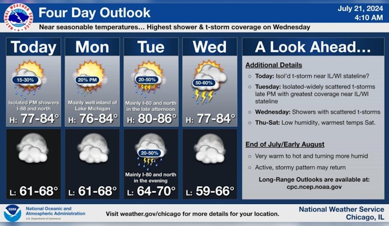
Near seasonable temperatures and occasional opportunities for showers and a few storms are expected through midweek. Looking ahead, a warmer and stormier pattern may return toward the end of July. #ILwx #INwx pic.twitter.com/M9hmOHreiK
— NWS Chicago (@NWSChicago) July 21, 2024
According to a post by NWS Chicago, after navigating through possible showers and storms until midweek, the area is potentially facing a return to a warmer and stormier climate towards the end of July. Residents and visitors should therefore keep an eye on updates as weather patterns evolve. While the city will experience near-seasonal temperatures for now, the latter part of the month could bring a significant shift in weather dynamics.


