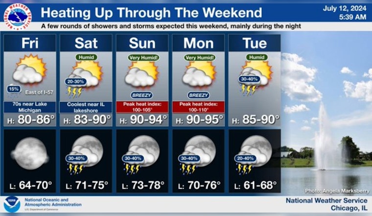
Chicagoans can look forward to a sunny and warm Friday, with the thermometer set to hit a high near 78 degrees. The evening will remain calm and mostly clear, with a low of around 70 degrees, while the weekend is shaping up to a moderate increase in temperature, as per the latest reports from the National Weather Service.
Today will be a pleasant, warm summer day across the area. Conditions get hotter this weekend with oppressive or even dangerous heat expected on Sunday and Monday. Additionally, we find a few chances for rain and storms through the weekend, primarily during the nighttime. pic.twitter.com/0XQS3OfsGm
— NWS Chicago (@NWSChicago) July 12, 2024
The weather is expected to become more dynamic as the week progresses. Saturday brings about a 20 percent chance of showers and thunderstorms, especially during the night. The day otherwise remains mostly sunny with a high soaring near 85 degrees. In a twist, isolated thunderstorms may "develop this afternoon east of I-57," as the Hazardous Weather Outlook details. However, spotter activation will not be necessary today or tonight.
Sunday warns of a spike in temperatures, with a scorching high near 94 degrees. The steamy climate carries through to Monday, with the NWS Hazardous Weather Outlook cautioning of "elevated excessive heat risk," expecting heat indices to "approach or exceed 100 degrees." Those planning outdoor activities should remain hydrated and take frequent breaks in the shade.
"Conditions get hotter this weekend with oppressive or even dangerous heat expected on Sunday and Monday," as per a statement by the NWS Chicago.


