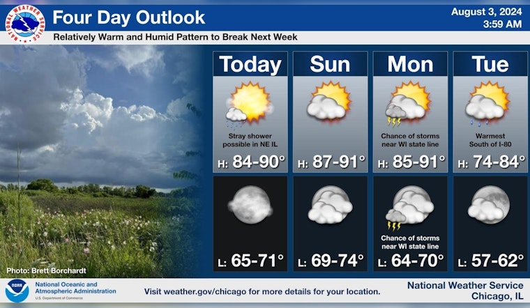
As Chicagoans navigate through another simmering August, the Windy City braces for a dance with temperamental weather patterns over the coming days, per multiple reports. The National Weather Service Chicago/Romeoville IL has issued a detailed forecast, finding no immediate peril in today's weather but hinting at potential disruptions as the week unfolds. According to the forecast on Weather.gov, today's sunny skies will give way to a 20 percent chance of showers with a high near 85, winds potentially ambling from the north-northwest to northeast.
The city's skyline could find itself skirted by storms with a slight chance of showers late Sunday night, and chances for thunderstorms seem poised to escalate slightly by Monday. In a similar mild crescendo, the weather service states that there's a "Limited Thunderstorm Risk...with an associated: Level 1 of 5 Severe Thunderstorm Risk." For those looking forward to some Lake Michigan leisure, Tuesday carries a “High Swim Risk” as reported by Weather.gov.
Meanwhile, an advisory from NWS Chicago on X underscores this pattern, affirming the continuance of warm and humid conditions stretching into early next week, subsequently relieved by the aforementioned storm system come Tuesday. The lingering showers and storms will roam through northeastern Illinois, looming near the Wisconsin state line from Sunday night right through to Monday night.
The relatively warm and humid pattern will continue through early next week, and break in the wake of a storm system on Tuesday. Chances for showers and storms will continue today in northeastern IL, and near the Wisconsin state line Sunday night through Monday night. #ILwx #INwx pic.twitter.com/iB9JIVitaQ
— NWS Chicago (@NWSChicago) August 3, 2024
As we edge closer to the tail end of this meteorological sequence, Tuesday is anticipated to whisk away the rain, leaving behind a partly sunny archive with a high nearing a more temperate 73 degree.


