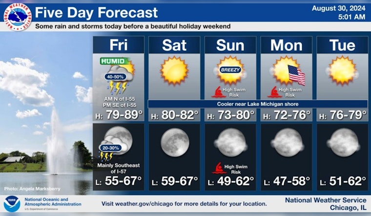
Chicago residents can expect a mix of weather patterns today, with showers and possible thunderstorms rolling through the area this morning, particularly northwest of I-55. The National Weather Service predicts that the weather will gradually clear up later in the evening, paving the way for a beautiful holiday weekend. Highs will be near 85 degrees with southwest winds shifting to west northwest in the afternoon.
However, there's a 60 percent chance of precipitation today, with the potential for gusty winds and localized stronger storms. By tonight, things are looking calmer; the chance of precipitation drops to 20 percent before 10 p.m. As reported by the National Weather Service, the wind will settle down too, coming from the north-northwest at around 5 mph.
The weekend's weather appears much more serene, with sunny skies and mild temperatures. Saturday will bring a high near 81 degrees with a light northwest wind, while Sunday cools down to a high near 75 degrees. The outlook for Labor Day itself is sunny with a high near 70. This pattern holds through midweek, with temperatures consistently close to a comfortable 75 degrees.
Scattered showers and a few storms will continue NW of I-55 this morning, with additional showers and storms expected SE of I-55 this afternoon/evening. Beautiful weather is in store for the long holiday weekend with cooler temperatures and no rain in the forecast! #ILwx #INwx pic.twitter.com/zyHN0NRJEv
— NWS Chicago (@NWSChicago) August 30, 2024
In a brief summary on Twitter, NWS Chicago stated that "Scattered showers and a few storms will continue NW of I-55 this morning, with additional showers and storms expected SE of I-55 this afternoon/evening." Consequently, while the storms may dampen plans today, the forecast for the days ahead promises plenty of sunshine for any outdoor Labor Day weekend festivities.


