Chicago is bracing for extreme weather conditions as a significant heat wave persists in the region. According to the NWS Hazardous Weather Outlook, "Hot and humid with will continue to build across the area today," with areas from Chicago experiencing heat index values reaching around 105 degrees. The heat is not only causing discomfort but also posing health risks, and residents are advised to prepare for a stretch of dangerously high temperatures that could be the highest of the year.
The impacts of heat are cumulative. With yesterday and today already being warmer than the past few weeks, the impact of the heat wave may sneak up on you! Here are the symptoms of heat related illnesses to watch for in yourself and your loved ones. #ILwx #INwx pic.twitter.com/XMhG0s6V5g
— NWS Chicago (@NWSChicago) August 26, 2024
An Air Quality Alert is in effect for northeastern Illinois, indicating that the air quality is at unhealthy levels for sensitive groups. The public is advised to limit prolonged outdoor activities, especially those with chronic respiratory illnesses. With the heat wave expected to peak on Tuesday, there is mounting concern for those vulnerable to heat-related illnesses, given that, "The impacts of heat are cumulative," and with rising temperatures over the past few days, the effects "may sneak up on you," as detailed by NWS Chicago.
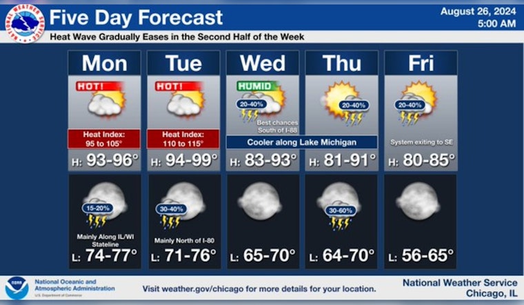
The heat wave will peak Tuesday this week, and gradually ease through the second half of the week. Cooler conditions will slowly move over the region into the weekend, accompanied by additional chances for showers and storms into Friday. #ILwx #INwx pic.twitter.com/3MAYS40IhG
— NWS Chicago (@NWSChicago) August 26, 2024
In light of the stifling conditions, local authorities suggest adjustments to outdoor plans including school sports practices. It's not just the heat that poses a threat, however; the region is also at a "Limited Thunderstorm Risk" with the potential for severe storms creating damaging winds and torrential downpours. The NWS Hazardous Weather Outlook forecasts a 40 percent chance of showers and thunderstorms late Tuesday afternoon, with storms potentially producing localized damaging wind gusts up to 60 mph.
Tuesday is predicted to be the most challenging day, sporting, "Significant to Extreme Excessive Heat Risk," and residents are urged to take "The impacts of heat are cumulative," seriously. The current weather pattern also raises flooding concerns, and by mid-week, there is expected to be some respite with a gradual easing of the heat, but still with a continued "Limited Thunderstorm Risk." For those seeking solace, the forecast anticipates cooler conditions moving into the area over the weekend, accompanied by additional chances for showers and storms into Friday, as noted by National Weather Service.


