Chicago's steady climate streak, marked by dry and cool weather, is expected to maintain its grip today, with the city basking in a sunny high near 79 degrees. According to the National Weather Service, residents can expect winds from the west-northwest around 10 mph, with gusts potentially reaching up to 15 mph.
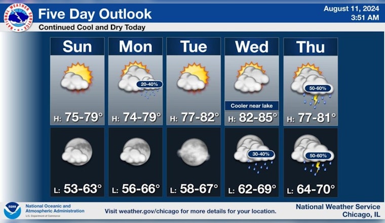
The dry and cool stretch of weather will continue today. Temperatures will then remain near to slightly below normal through the upcoming week. Some showers are possible Monday, but higher chances are expected later in the week. pic.twitter.com/YwMf3DVSl0
— NWS Chicago (@NWSChicago) August 11, 2024
The week ahead calls for temperate conditions to linger, with temperatures hovering near to slightly below typical for this time of year. There's a slim chance of showers come Monday afternoon, marked by a scant 20 percent probability of rain post-1 pm. While the National Weather Service forecasts a mostly sunny Tuesday, the calm before the atmospheric activities resumes as the week progresses, with Wednesday night unveiling a chance of showers after 1 am.
As reported by the NWS Hazardous Weather Outlook, no immediate weather threats are expected today or later into the night. However, as we venture into Wednesday through Friday, there is a "Limited Thunderstorm Risk" occasionally present.
For those making plans, the warmth of today gradually transitions to a slightly cooler atmosphere by nightfall, dipping to a low around 64. That said, if you're laying bets on the weather, the skies seem to be rolling the dice later in the week. As detailed by the NWS Chicago, the forecast points towards a higher chance for showers as the week unravels.


