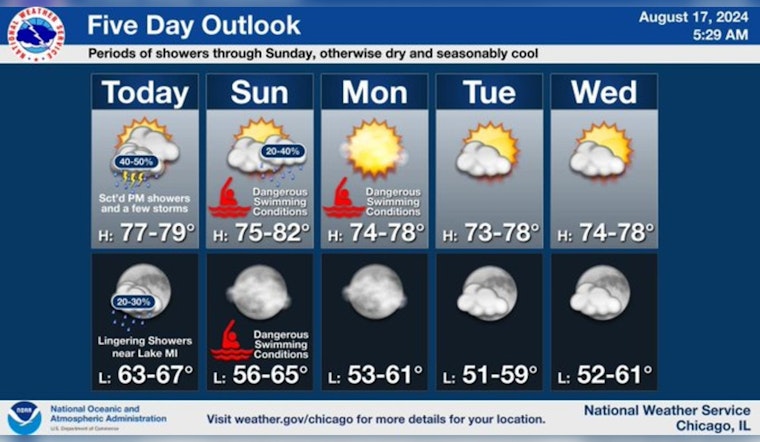
As unsettled weather patterns hover over Chicago, residents and visitors face showers and potential thunderstorms, alongside breezy conditions that bring high-risk warnings at local beaches. Today's forecast anticipates scattered showers and thunderstorms primarily before 5 pm, followed by a high likelihood of precipitation that could result in new rainfall reaching between a tenth and a quarter of an inch, according to the National Weather Service. The weather takes a brisk turn with temperatures hovering around the mid-70s to 80, settling into more predictable patterns after the weekend.
Chances for sct showers will persist through Sun followed by dry conditions for most of next week. Breezy northerly winds Sun and Mon will make for large waves and dangerous swimming at area beaches. Otherwise, expect seasonably cool temps in the 70s to around 80 #ILwx #INwx pic.twitter.com/CQbw3KqfbJ
— NWS Chicago (@NWSChicago) August 17, 2024
The outlook for tonight introduces a decreased chance of 30 percent for showers and thunderstorms, primarily tapering off before 9 pm. Winds from the northwest may reach 10 mph, gusting up to 15 mph, making for a chiefly clouded evening. On Sunday, the change in wind direction to the north and increasing speed set the stage for a High Swim Risk at Lake Michigan Beaches, a direct consequence of the anticipated large waves and dangerous swimming conditions, as "Large waves and dangerous currents are expected to develop Sunday morning and persist through Monday at southern Lake Michigan beaches," as stated by the Hazardous Weather Outlook.
Moving into the new week, Monday projects clear skies with sunny exposure, the north wind persisting but diminishing in potential disruptions to daily activities. Those conditions are expected to stay consistent through to Wednesday, with a forecast of sunny days ahead and nighttime lows settling comfortably in the 60s. "Chances for sct showers will persist through Sun followed by dry conditions for most of next week," as echoed by the NWS Chicago.
Chicago's residents should remain vigilant, particularly when planning outdoor or waterfront activities. The National Weather Service advises that the general storm movement for today will be southeast-bound at 25 to 30 mph, ensuring that any outdoor plans are timed accordingly, and caution is exercised near water bodies. Looking forward to the latter half of the week, from Tuesday to Friday, the community can expect a steady climb with temperatures reaching the high 70s and culminating near 83 on Friday, offering Chicago a semblance of summer warmth amidst unpredictable weather patterns.


