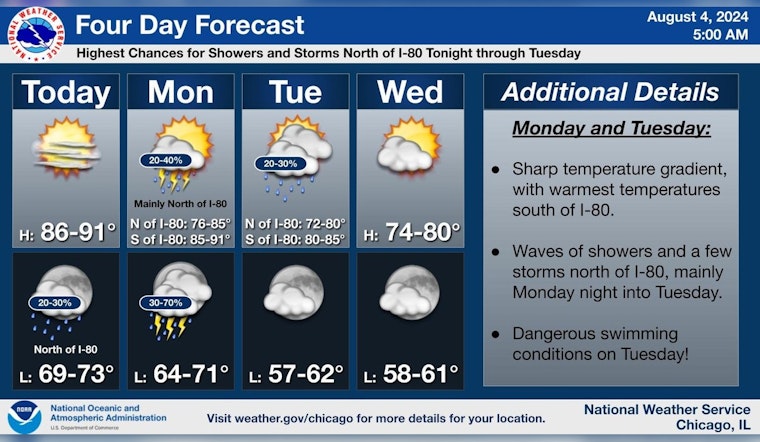
Chicagoans are bracing for a mix of weather conditions this week, as sunny skies give way to potential thunderstorms and cooler temperatures. The National Weather Service predicts a high near 90 degrees today with mostly sunny weather, while conditions tonight may lead to a 20 percent chance of showers and thunderstorms after 1 am.
As the week progresses, Monday holds a 30 percent chance of storms, mainly before 1 pm, shifting to cooler and more precarious conditions north of I-80. The Hazardous Weather Outlook indicates a "Limited Thunderstorm Risk tonight north of I-80," with possible scattered thunderstorms arriving from southern Wisconsin late in the day and additional storms tracking into northern Illinois during the late overnight hours.
Looking further ahead, Tuesday will bring cooler highs near 73 degrees and a 40 percent chance of rain, with a risk of severe thunderstorms and a "High Swim Risk" for Lake Michigan beaches, reports the National Weather Service. This is followed by Wednesday's sunny outlook, boasting a high near 74 degrees, giving residents a brief respite from the rain.
Mariners will also need to exercise caution, as hazardous conditions for small craft are likely on Monday, according to the weather outlook. The National Weather Service alerts the potential for "Hazardous conditions for small craft are likely," which means those planning activities on Lake Michigan should stay informed and prepared for sudden weather changes.
A forecast post shared by the National Weather Service Chicago on social media advises that "Monday and Tuesday, a front will stall across the area, leading to hot and humid conditions south of I-80," making it imperative for individuals in these regions to stay hydrated and find ways to stay cool. By the time we reach the weekend, the sunny trend returns with a high near 74 on Saturday.


