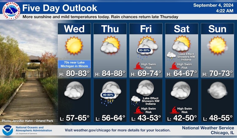
As residents of Chicago bask in the sunny weather with high temperatures near 79 degrees today, a shift in conditions is expected. According to the National Weather Service forecast, the pleasant clear skies will however soon give way to an elevated chance of showers and thunderstorms with temperatures cooling down by the end of the week.
The forecast predicts that the warmth will linger through Thursday, with mostly sunny skies and a high approaching 87 degrees, while Thursday night's weather brings a 50 percent chance of showers and thunderstorms. These potentially disruptive weather patterns, circling in from the southwest with breezes that might gust as high as 15 mph, are forecasted to crest by Friday. During their morning commute, Chicagoans should anticipate a 30 percent chance of showers, mostly before 1pm.
By Friday night, the likelihood of showers dwindles to 20 percent before 1am, setting the stage for a partly cloudy sky and a cooler low around 52 degrees. The weekend looks clear and sunny with highs in the mid-60s, perfect for those planning outdoor activities. Continuing into the early week, sunny skies will prevail with temperatures climbing again, with Monday expected to reach a high near 80, as detailed in forecasts by NWS Chicago.
Today, expect mostly sunny skies with highs in the lower 80s (cooler near the Illinois shore). One more warm day is in store tomorrow before rain and storm chances cool us off for the end of the week. #ILwx #INwx pic.twitter.com/DtzgiCha5R
— NWS Chicago (@NWSChicago) September 4, 2024
Amidst this weather shift, The National Weather Service has also issued a Hazardous Weather Outlook, alerting lake enthusiasts to high swim risks along Lake Michigan beaches from Friday to Saturday. According to the announcement, hazardous conditions for small craft are likely. Thus, casting a shadow on a seemingly benign weather forecast, are signals from the skies that caution should be exercised by those drawn to the water's edge.
Chicagoans near Lake Michigan in Indiana should also be aware of a limited thunderstorm risk that mirrors Thursday's forecast. Nonetheless, there is no current need for spotter activation, offering a sliver of hopeful insight that the coming days, despite their tumultuous meteorological predictions, may pass without severe incident. Residents and visitors alike should stay tuned for updates and prepare to adjust their plans accordingly as the forecast evolves.


