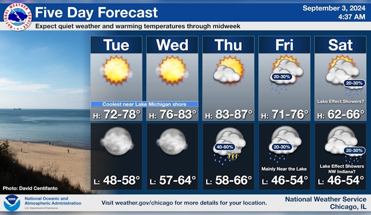
Chicago residents can look forward to a blend of sunny skies and potential showers as the week progresses, according to the latest forecasts. The National Weather Service has predicted that today will be sunny with a high near 74 degrees, and winds shifting from south-southeast in the morning to east in the afternoon. The evening is anticipated to remain mostly clear with temperatures dropping to around 59 degrees.
However, the tranquil weather is slated to change later this week. The National Weather Service, in a detailed forecast, suggests that Thursday night could bring a chance of showers, followed by likely showers and possibly a thunderstorm after 1 a.m. This pattern is poised to bring a cooldown with a 60 percent chance of precipitation expected. Coming into the weekend, while there is a chance of showers before 1 p.m., the skies are projected to clear by Saturday, boasting a sunny high near 65 degrees.
For those planning to visit the beaches along Lake Michigan, the weather outlook indicates a need for caution. According to the National Weather Service's Hazardous Weather Outlook, there's a "High Swim Risk" starting Friday and extending into Saturday due to likely hazardous conditions for small craft.
In anticipation of these fluctuating conditions, beachgoers and boaters should prepare for a potential uptick in dangerous rip currents and waves. "Hazardous conditions for small craft are likely," warns the National Weather Service, as Thursday ushers in the mentioned limited thunderstorm risk. The weather service advises individuals with waterfront plans to stay informed and exercise caution during this period.
Fitting into this narrative of changeable weather, a post from NWS Chicago confirms a warming trend over the next few days, but signals a "big cooldown in store for the weekend." This information might suggest layering and remaining adaptable to the oscillating temperatures for anyone enjoying the city's outdoor offerings.


