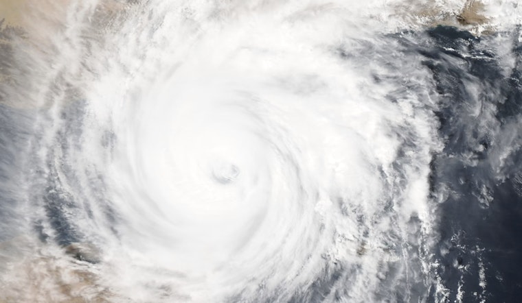
Miami braces for turbulent weather as Hurricane Helene advances towards the Florida coast, bringing with it a mishmash of tumultuous conditions. According to the National Weather Service, today's outlook includes a potential for tropical storm conditions, showers likely, and thunderstorms both before and after 11am. Residents can expect a high near 89 degrees with heat index values soaring to as high as 103 degrees. The likelihood of precipitation stands at 60%, with new rainfall amounts between a quarter and half of an inch possible.
The National Weather Service reports visibility standing moderately clear at 10 miles, despite the humidity in the air which hangs at a heavy 80%. The surging storm impacts not just the skies but also churns the ocean into treacherous territory.
NBC Miami details the conditions in the Lower Keys, presently facing the fury of Hurricane Helene's outer bands, with wave heights reaching a staggering 10.2 feet. Flood watches linger in effect, underscoring the severity of anticipated downpours—local areas might witness rainfall accumulating between 2 to 4 inches, and up to 6 inches in isolated events, leading to possible flood conditions. The news outlet notes the precariousness of the storm surges, although areas like Broward and Miami-Dade counties may be spared the brunt of the surge expected to hammer the Florida Keys.
Winds form a significant part of the immediate menace, with the National Weather Service recording a feverish dance of south winds blowing at 20 to 25 mph, gusting up to 45 mph tonight. The onset of these strong winds not only stirs the sea but also shakes the very foundation of normalcy on land. Communal disruptions, including the jeopardy of wind-related damages and travel disturbances, are a near certainty as the tempest marches onward.
The fierce gales also carry the seeds of transient but potentially destructive tornadoes. As Hurricane Helene churns its course, it stokes a volatile atmosphere ripe for these quick-forming vortices. Southwest Florida has already seen several tornado warnings, a response to the capricious weather. Miami has registered winds topping at 39 mph and Pompano, slightly more vigorous, at 44 mph, as early as 6:30 a.m. The sustained winds are expected to intensify as the hurricane keeps a distance of approximately 350 miles to the west of the area. Meteorological forecasts by NBC Miami indicate that these blustery conditions will persist throughout Thursday, with a hopeful dissipation paving the way for calmer weather over the weekend.
Residents are urged to stay informed and prepare for the range of conditions that could unfold. With showers and thunderstorms likely before and after sunset, availing oneself of current weather updates and safety advisories is the prudent course of action. The brunt of Hurricane Helene carries a mix of hazards, including the threat of flooding and destructive winds—contingencies best faced with foresight and readiness.


