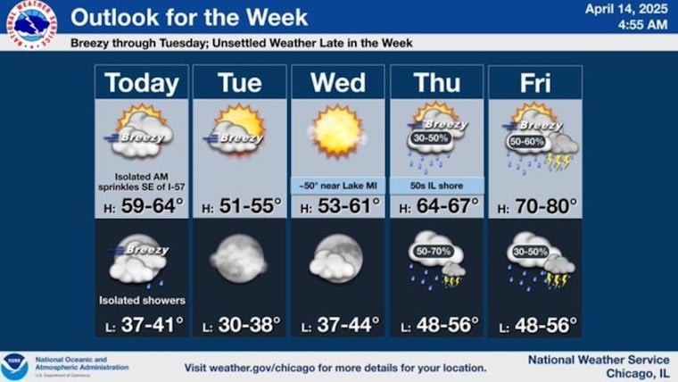
As Chicagoans savor the mild spring weather, they're hitting the third consecutive day with highs in the 60s. Despite the arrival of a cold front this morning, the city will only see a few light showers. The rest of Monday will be windy and partly to mostly cloudy, with wind speeds picking up in the afternoon, gusting as high as 35 mph, according to the National Weather Service.
Gusty west winds are expected today followed by blustery northwest winds on Tuesday. Rain and thunderstorm chances will increase late in the week. pic.twitter.com/qNnEJfPf4k
— NWS Chicago (@NWSChicago) April 14, 2025
The coming days promise a continuation of this temperate stretch. Tuesday will cool slightly, with highs anticipated in the lower 50s and a small chance of light showers early in the morning. Winds will remain brisk, at times surpassing 30 mph gusts, as reported by FOX 32 Chicago. Evening lows will drop to the upper 30s.
As midweek approaches, Chicagoans can expect mostly sunny skies on Wednesday, with highs persisting in the 50s, as per FOX 32 Chicago. The pleasant weather is set to shift on Thursday, warming up to the 60s again under partly sunny conditions. However, this will come with a 30 percent chance of showers and possible thunderstorms by evening.
Friday heralds the warmest day in this forecast series, with temperatures climbing well into the 70s, as detailed by FOX 32 Chicago. Admittedly, this warmth does come with a caveat — a likelihood of thunderstorms that could pack a robust punch. By Saturday, the city will again experience mild breezes and highs approaching 60, but skies remain on watch for weekend showers and thunderstorms, especially by Sunday.


