Chicagoans, brace yourselves for a weather rollercoaster as the city transitions from a breezy and cloudy day through a midweek warmth spell before thunderstorms beckon the weekend's cool down. Today's forecast is "Mostly cloudy, with a high near 56," and wind gusts potentially reaching 35 mph, as reported by the National Weather Service.. After a windy day, skies will clear with evening temperatures around 44 degrees.
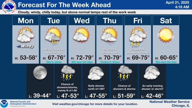
The work week will start out windy, seasonably cool, and plenty of cloudiness. After today, the rest of the work week should feature above average temperatures (though frequently cooler near the lake) and occasional chances for showers and storms. pic.twitter.com/2R4BrwckFw
— NWS Chicago (@NWSChicago) April 21, 2025
Tuesday brings a 20 percent chance of showers and storms after 1 p.m., with highs near 69 degrees and gusty south-southeast winds over 20 mph. Rain chances increase by Friday, followed by a cooler, drier weekend. The mercury will climb even higher as we reach Wednesday, with the National Weather Service forecasting a "slight chance of showers and thunderstorms" later in the day under "Partly sunny" skies and highs nudging 63 degrees.
"Thursday could be the warmest day of the week with highs, not far from 80 under partly sunny skies," as stated by Fox 32 Chicago. However, with a cold front anticipated by the end of the week bringing scattered showers and potentially stirring thunderstorms as Friday will see the highs around 71. The cool embrace of the weekend forecast specifies, "The weekend looks cooler but dry with highs around 60°."


