Chicago's local forecast predicts a pleasant start to today with sunny skies and a high of 61 degrees, accompanied by an east wind traveling at a moderate pace of 5 to 10 mph, gusts could potentially reach 20 mph later in the day. This evening is expected to remain mostly clear with a temperature drop to around 52 degrees, while winds shift to a south-southeast direction at around 10 mph.
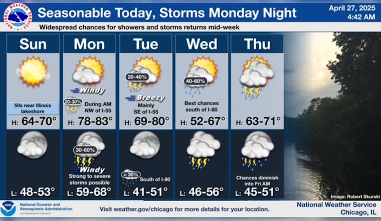
As we usher in the workweek, Monday promises to deliver a significant surge in temperature, seeing the thermometer climb close to 80 degrees—marking a substantial jump from today's temperate conditions, the south wind will pick up speed ranging from 10 to 20 mph, and it's forecasted that gusts could peak up to 30 mph, creating a breezy and very warm environment that could potentially escalate into stormy weather conditions overnight and into the early hours of Tuesday. According to a CBS News Chicago report, this weather shift as part of a warming trend starting Sunday.
Looking towards Monday night, the possibility of showers and thunderstorms looms, pegged at a 40 percent likelihood, mainly post 1 am, and with breezy conditions persisting, the nighttime low is poised to hit around 66 degrees with wind speeds reaching up to 25 mph and gust strength that might surge as high as 40 mph. Weather developments continue to demand attention as the Storm Prediction Center places Chicago at a Level 2 for the possibility of severe storms, indicating a time of vigilance for residents and local authorities alike.
Chicagoans should expect a gradual decrease in storm risk by Tuesday with a 20 percent chance of showers and thunderstorms scattered throughout the day before 10 am, then again slightly between 10 am and 1 pm, and once more after 1 pm, while the sun makes a partial return, helping the day achieve a high of roughly 76 degrees despite the breezy southwest winds that are set to shift west northwest in the afternoon; winds could briskly gust as high as 35 mph according to the forecast from the National Weather Service.
The rest of the week maintains an unsettled pattern with a 40 percent chance of showers ushering in a cooler Wednesday, a cloudy high near 56 degrees, with further likelihood of showers intensifying Wednesday night particularly after 1 am, setting up Thursday to contend with likely showers and a high near 67 degrees.
Heading towards the weekend, weather predictions suggest a return to calmer skies, as Friday is anticipated to be mostly sunny with a high around 60 degrees, and Saturday continues the trend with clear skies and a comfortably cool high near 59. Chicago's fluctuating springtime climate reminds us of its capacity for swift transformations, promising a blend of warmth, wind, and water in the days to come.


