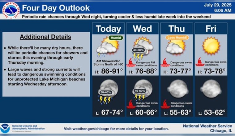
Chicago residents brace for another day of sweltering heat as temperatures are expected to soar into the low to mid-90s, following a similar pattern to the previous day. According to the National Weather Service, there is a " 20 percent chance of showers and thunderstorms after noon" with partly sunny skies and a high near 91 degrees.
The humidity shows slight signs of relenting; however, the city is not entirely out of the woods yet, as there remains a "slight chance of showers and thunderstorms before 10pm, then a slight chance of showers and thunderstorms after 4am," leading to a mostly cloudy night with lows around 73 degrees, but worry not, a cold front is on its way offering some reprieve from the current muggy conditions. FOX 32 Chicago reports that the lake breeze might tip the scales once more, possibly igniting isolated thunderstorms laden with heavy rainfall and gusty winds later in the day.
Change is imminent with the advent of Wednesday as a cold front is expected to migrate through the Chicago area, bringing a dip in temperatures and stirring up bouts of thunderstorms well into Thursday. The National Weather Service predicts a "40 percent chance of showers and thunderstorms, mainly after 7am" with highs around 79 degrees on Wednesday, and a continued 50 percent chance of wet weather enduring into Wednesday night.
There is light at the end of the tunnel, as weather patterns are set to shift post-Thursday; the region is slated to experience "spectacular" conditions, marked by a considerable decline in humidity and respite from the heat, skies will break for sunshine and temperatures will edge down, promising a series of days with abundant sunshine and highs comfortably pegging in the low 80s, offering Chicagoans a well-deserved break from the relentless grip of summer's high-stakes temperament.


