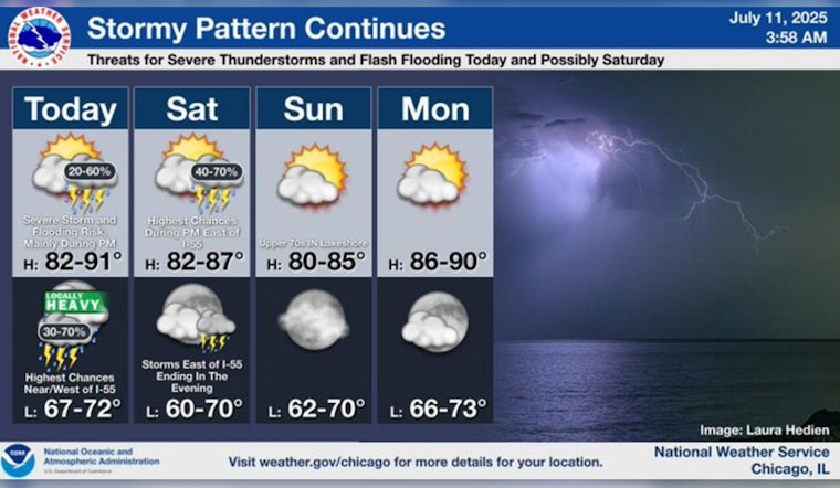
Chicagoans braced for a potentially tumultuous weather weekend as forecasts and reports indicated a mix of storms, humidity, and the possibility of severe weather conditions. According to the National Weather Service, there was a 50 percent chance of showers and thunderstorms on Friday, particularly in the late afternoon, with concerns over heavy rainfall and the potential for storms producing hail and gusty winds.
The situation seemed grim early Friday morning as severe storms led to operational halts at O'Hare Airport and forced an evacuation at the Windy City Smokeout festival, as NBC Chicago reported, the storms also caused power outages affecting nearly 3,000 people, based on ComEd's Outage Map, while heavy rain led to multiple crashes and hazardous driving conditions exemplified by the flooding captured in photos and video at LaSalle's underpass on DuSable Lake Shore Drive that resulted in an underpass being partly submerged.
The likelihood of rain and thunderstorms would continue through Friday night, with the National Weather Service forecasting a 50 percent chance of continued storms and a predicted low of around 71 degrees. Conditions on Saturday would not provide much reprieve, with a 60 percent chance of thunderstorms, especially past 1 p.m., while winds could reach gusts as high as 20 mph amidst temperatures peaking near 86 degrees.
As Chicagoans planned their weekend, the looming threat of severe weather prompted caution with the National Weather Service suggesting that new rainfall could measure between a tenth and a quarter of an inch, yet thunderstorms could bring higher amounts, such precarity was underscored by NBC Chicago's meteorologist Kevin Jeanes warning of a "slight" risk of severe weather by late afternoon on Friday, noting that "the biggest threat being wind damage" but also conceding that "flash flooding is possible, and there's a slight risk of tornadoes -- can't rule that out."
As the weekend progressed, a clearer outlook emerged for Sunday, which was anticipated to be mostly sunny with a high near 85 degrees, according to the National Weather Service forecasts, leading to a less humid day compared to its predecessors. The following evenings were expected to be mostly clear with lows in the upper 60s and 70s, providing a momentary reprieve before Tuesday when the chance of storms re-emerges and temperatures ascend toward the low 90s.


