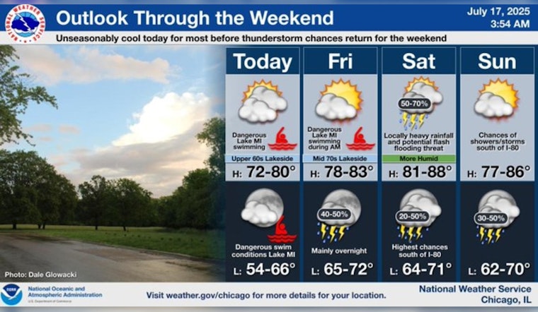
Chicagoans are bracing for a shift in weather conditions, with forecasts predicting the end of a warm stretch and the onset of an impending heat wave next week. After several days with high temperatures consistently above the 80-degree mark, the city is expected to experience a slight cool down. Today's temperatures are expected to linger in the upper 60s, a relief especially for those near the lake and in the northern regions of the area, as reported by FOX32 Chicago. Cloud cover is to remain partly to mostly over the sky, with any precipitation likely staying south of the Chicagoland area.
Looking ahead, the weather for tomorrow is anticipated to be pleasant, with temperatures rebounding to the lower 80s and partly to mostly sunny conditions, allowing everyone to enjoy a beautiful summer day. As the weekend approaches, NOAA forecasts suggest showers and thunderstorms for Saturday, coupled with high temperatures in the low to mid-80s. Sunday's outlook is much drier, offering partly sunny skies and comparable temperatures.
As for the week to come, Chicago is set to experience the season's most intense heat so far. Starting Monday, the heat is expected to ramp up, with mid-80s, ascending to low 90s by Tuesday and reaching mid-to-upper 90s by Wednesday. Coupled with this heat surge, the city will likely see a rise in humidity levels, potentially necessitating heat advisories from weather officials.
While high temperatures are a central concern, a potential tempering factor could be the occurrence of thunderstorms. Such storms sometimes accompany these hot patterns and might hold the temperatures down or, at least, bring some temporary relief. However, given the current timing being too far out, confidence regarding the timing of these thunderstorm clusters remains low, as stated by FOX32 Chicago. Residents interested in staying updated with the latest weather developments can rely on resources like NOAA and local news outlets for real-time information.


